Archaeological ruins of Urartu (858 – 585 BC) in north-west Iran
(From 1 to 9, Table of contents with photos, texts and links)
1-Archaeological ruins of Urartu (858 – 585 BC) in north-west Iran
2-Urartu became a major power, able to rival its Assyrian neighbor
3-Meher Kapısı inscription in Urartian text
4-The Musasir Temple of Urartu
5-Urartu Stele, King Ishpuini, 800 BC.
6-The Kingdom of Urartu was rich in bronze and iron resources
7-The end of Urartu.
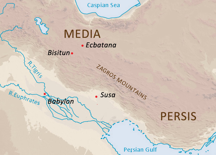
8-The beginning of Armenia: Inscription of Behistun Iran (Inscribed by UNESCO in 2006)
9-Remains of the Urartian archeologique sites outside of Iran
+
(From 10 to 21, Table of contents with photos, texts and links)
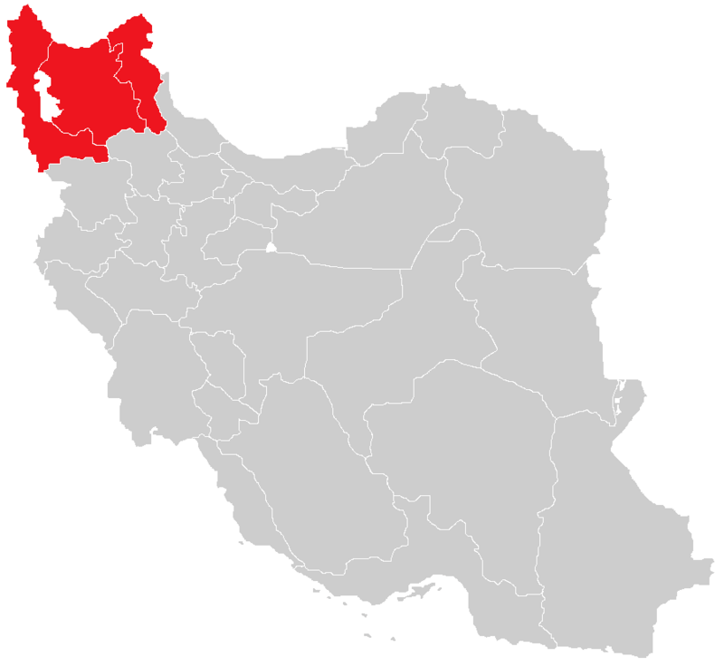
URARTU IN IRAN
10-URARTU archaeological sites in Iran
11-The Kingdom of Urartu and the Lake Urmia in Iran
12-On the shores of Lake Urmia remains of the first stage of the Koura-Araxes culture (3500–2200 BC)
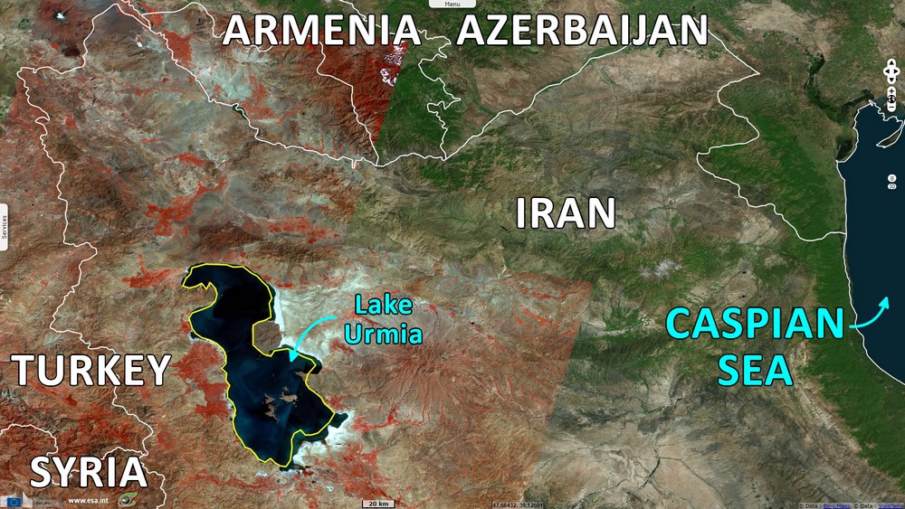
13-Lake Urmia is located in the Iranian province of Azerbaijan
14-Historic Urartian village in Chors, Iran
15-Urartu fortress of Bastam, Iran
16-Urartu Castle in Qoban, Iran
17-Urartu Bari Castle, Urmia Lake Iran
18-Urartuian catacombs (858 – 585 BC)
19-Urartu cuneiform inscriptions in Iran
20-Urartian Bulla from Ziwiye in the northwestern of Iran
21-Bronze Bracelet with Urartian Inscription from Toul, Gilan, Iran


(1)
Archaeological ruins of Urartu (858 – 585 BC) in north-west Iran
The earliest traces of Urartu’s history can be traced back to clay tablets in Assyrian cuneiform script, as well as archaeological discoveries and the collection of several ancient texts.
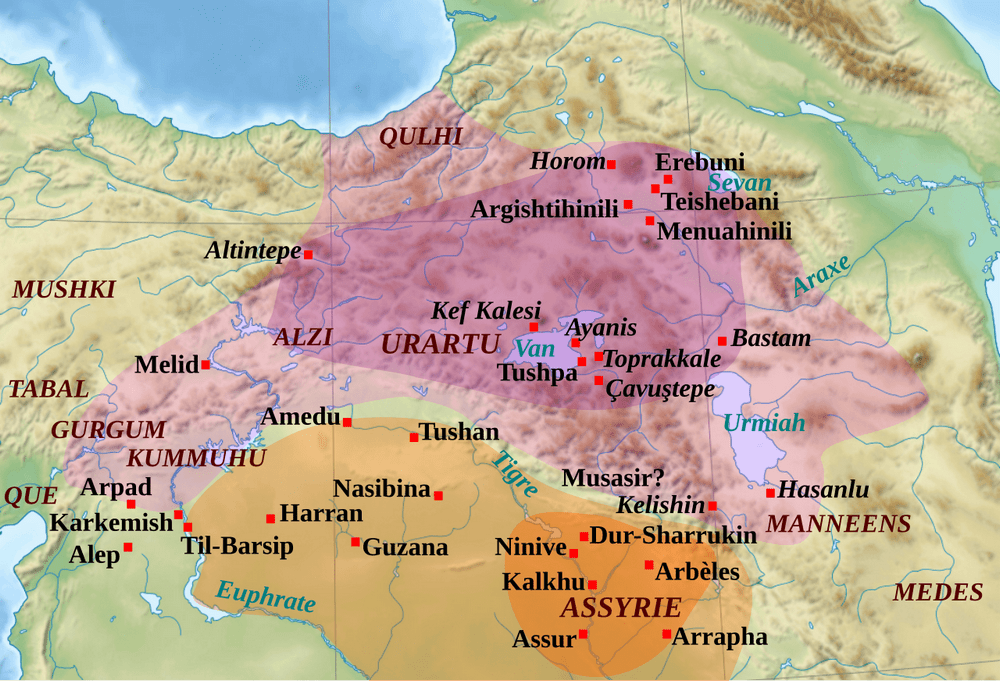
When Urartu organized itself into an Empire, it reached its apogee, covering a territory stretching from the high valleys of the Tigris and Euphrates to Lake Van, extending as far as Lake Sevan and Lake Urmia.
The historic location of Urartu will change names throughout history, but one of the earliest known names was Biainili and its capital was Tushpa. Tushpa takes its name from the Urartan Goddess Turushpa.
But the first kings of Urartu referred to their kingdom as Nairi, a name of Akkadian origin.
And for the Babylonians, Urartu was known as Urašu. The Babylonian map of the world (Mappa Mundi), places Urartu among the most important places in the then known world.
Moreover, the Biblical reference to Noah’s Ark on the mountains of (Ararat) actually refers to the mountains of (Urartu). The name “Urartu” has been replaced by a Hebrew version of “Ararat”, meaning “The scourge is overthrown”.
And in Persian this mountain is known as “Kūh-e Nūḥ” which literally means “Noah’s Mountain”.
Urartu was located on the Armenian mountain plateau, between Mesopotamia, the Iranian Plateau and the Caucasus Mountains.
Nowadays, some of Urartu’s archaeological sites can be found in Armenia, in Iran and in Turkey.
Photos from 1 to 6
1-Biainili (Geographic map with the name Biainili)
https://garystockbridge617.getarchive.net/topics/maps+of+urartu
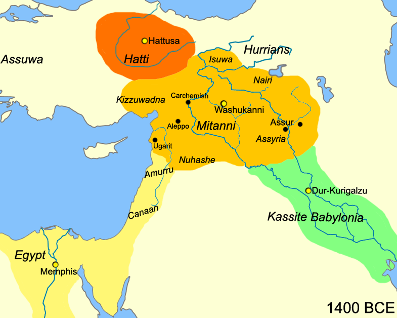
2-Near_East_1400_BCE (Geographic map with the name Nairi)
https://fr.wikipedia.org/wiki/Nairi
3-Babylonian Mappa Mundi-Urartu
https://fr.wikipedia.org/wiki/Carte_babylonienne_du_monde
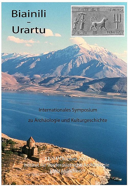
4-This website is devoted to archaeological and historical research in the area of the ancient near-eastern kingdom of « Biainili », better known by the Assyrian name « Urartu ».
http://www.biainili-urartu.de/
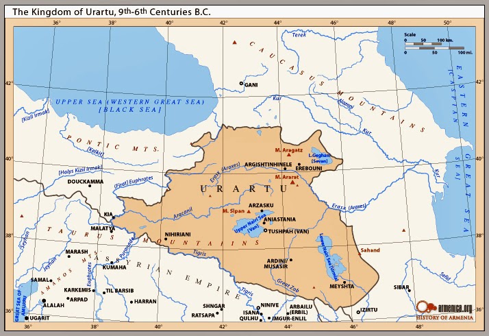
5-Kingdom of Urartu 9th_6th Century B.C.
https://ancawr.org/press-release/the-ancient-kingdom-of-urartu/
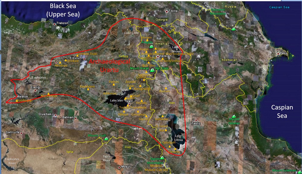
6-Urartu Archaeological Map Borders (Red) with Urartian Archaeological Sites (Orange) based upon Dr. Paul Zimansky’s and H. Kessler’s Research and the Mountain Buffer Zones of the Gordyene, Taurus, and Zagros Mountains.
https://www.noahsarksearch.com/resources/overview/
*
-ASSYRIANS AND URARTIANS
https://www.ucl.ac.uk/sargon/downloads/radner_ohaa_2011.pdf
-Urartu: The Kingdom of Van Opposition for the Assyrians
https://warfare.x10host.com/Ancient/Urartu.htm
*
-In earlier Akkadian texts, Urartians use the name Nairi for their land, which in Middle Assyr- ian and early Neo-Assyrian documents appears to refer to a highland area to the south and east ofUruatri, closer to Lake Urmia.
The kings of Biainili do not provide an ethnic or linguistic designation for their subjects, beyond the literal meaning of Biainili itself, « those of the land of Bia:’ Because this was an empire put together by military force and importation of captive peoples, the assumption that there was broad ethnic or linguistic uniformity among its subjects is hardly warranted.
After the collapse of both Biainili and the Assyrian Empire, there are scattered cuneiform references to the land of UraStu and individuals in some way associated with it. In the absence of an autonomous political entity in the area at this time, the term is probably once again geographical.
The Behistun trilingual of the late sixth century B.C.E. uses Urastu in the Akkadian version, but replaces it with Armina and Arminiya in the Old Persian and Elamite versions, respectively (King, Thompson, and Budge 1907:1)-the first historical appearance of the term Armenia (see Radner, chapter 33in this volume). If there ever had been a linguistic connotation to UrartuJ Urastu, by this time it must have been a thing of the past.
https://www.academia.edu/10023756/Urartian_and_the_Urartians
-NAIRI TRIBAL CONFEDERATION
Nairi was the Akkadian name for a region inhabited by a particular group (possibly a confederation or league) of tribal principalities in the Armenian Highlands, approximately spanning the area between modern Diyabakır and Lake Van and the region west of Lake Urmia.
https://history-maps.com/story/History-of-Armenia/event/Nairi-Tribal-Confederation
-Where did the Urartians come from? Before their rise as an Empire in the 9th century BC, they were a powerful tribe which belonged to a federation led by the Nairi.
http://www.tacentral.com/erebuni/history.asp
-Nairi
https://www.armeniapedia.org/wiki/Nairi
*
-In the Bible, Urartu is referred to as « Ararat. » This name appears several times in the Old Testament, particularly linked with the stories of post-Diluvian ancestors of humankind.
https://digitalbible.ca/article-page/bible-study-biblical-locations-where-is-Urartu-1699763951333×959382872255606100
-The Biblical reference to Noah’s Ark on the “Mountains of Ararat” designates the mountains of Urartu, an iron age kingdom that grew into a major power from the 13th to the 9th century BC. The 1947 discovery of the dead sea scrolls verified that ‘Ararat’ was derived from “Urartu” by the Greek substitution of the letter “a” for vowels within the Hebrew form written only with consonants (rrt).
https://www.armenianmuseum.org/ancient-armenia
-ARARAT ăr’ ə răt (אֲרָרַ֖ט). A country in Armenia, its center being Lake Van.
According to Genesis 8:4, Noah’s ark came to rest, after the waters subsided, on “the mountains of Ararat.” If the Biblical Flood overtook Noah somewhere in Mesopotamia, then the highest mountains in the vicinity, which the receding waters would have first exposed, would have been those in the N (Urartu). 2 Kings 19:37 and Isaiah 37:38 record the fact that two sons of Sennacherib, called Adrammelech and Sharezer in the OT, killed their father and fled to the land of Ararat (Urartu). This statement is partially confirmed by the Babylonian Chronicle (iii 34-38). The extra details given in the OT are by no means improbable or tendential. The association in Jeremiah 51:27, 28 of Ararat, Minni (Maneans), Ashkenaz (Scyths), and Medes accords with the military situation of the early 6th cent. b.c., when Urartu, Maneans, Scythians, and Medes were all active.
https://www.biblegateway.com/resources/encyclopedia-of-the-bible/Ararat
◇─◇


(2)
Urartu became a major power, able to rival its Assyrian neighbor.
And at that time Urartu was also neighbors with another Kingdom, the Mana Kingdom (Biblical name Minni/Mannai) established in the west of Lake Urmia in Iran.
The Urartians spoke a language related to Hurrian, spoken by Indo-Iranian tribes in northwestern Iran, a language with no other known links.
The Hurrians are known in the Bible as the Horites. The Horites were a people who had very close relations with Abraham’s family and the Edomites.
Urartu’s capital, Tushpa, was built on a limestone hill on the eastern shores of Lake Van. Tushpuea was an Urartuan Goddess from whom the city of Tushpa takes its name.
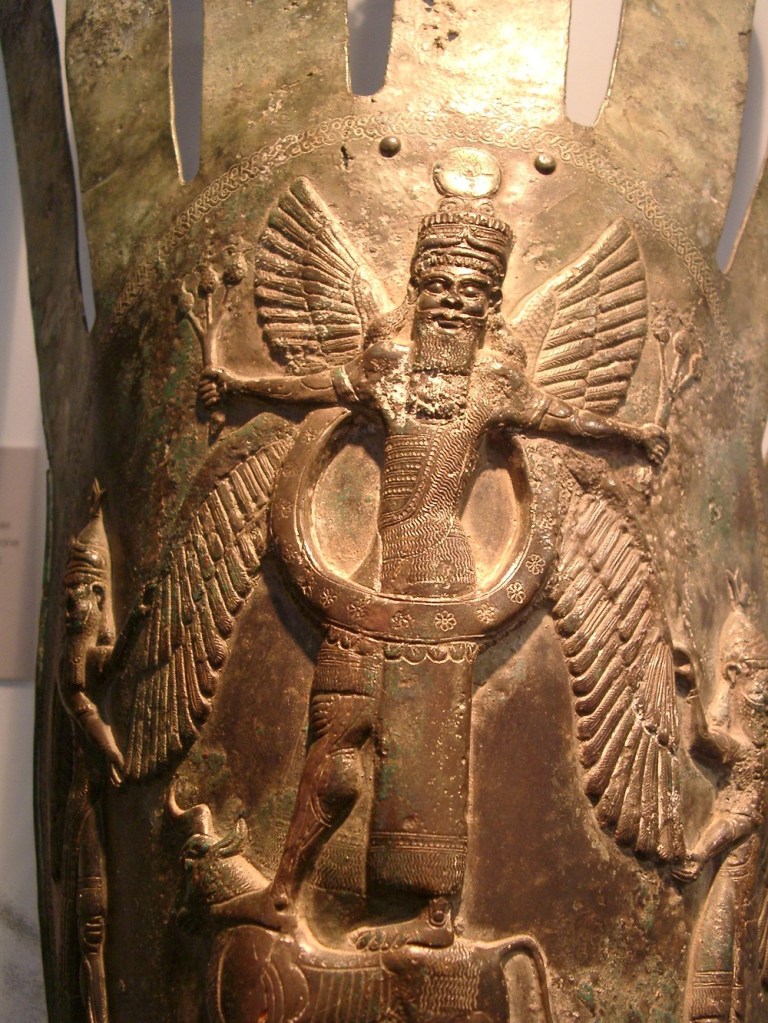
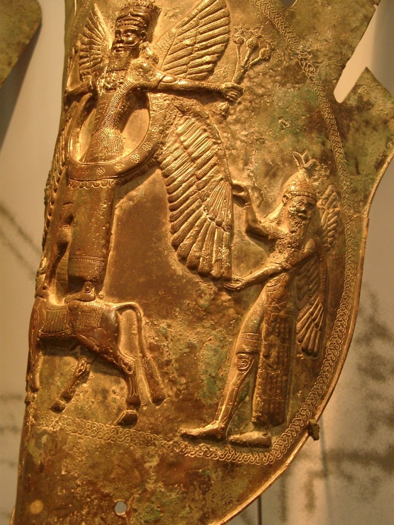
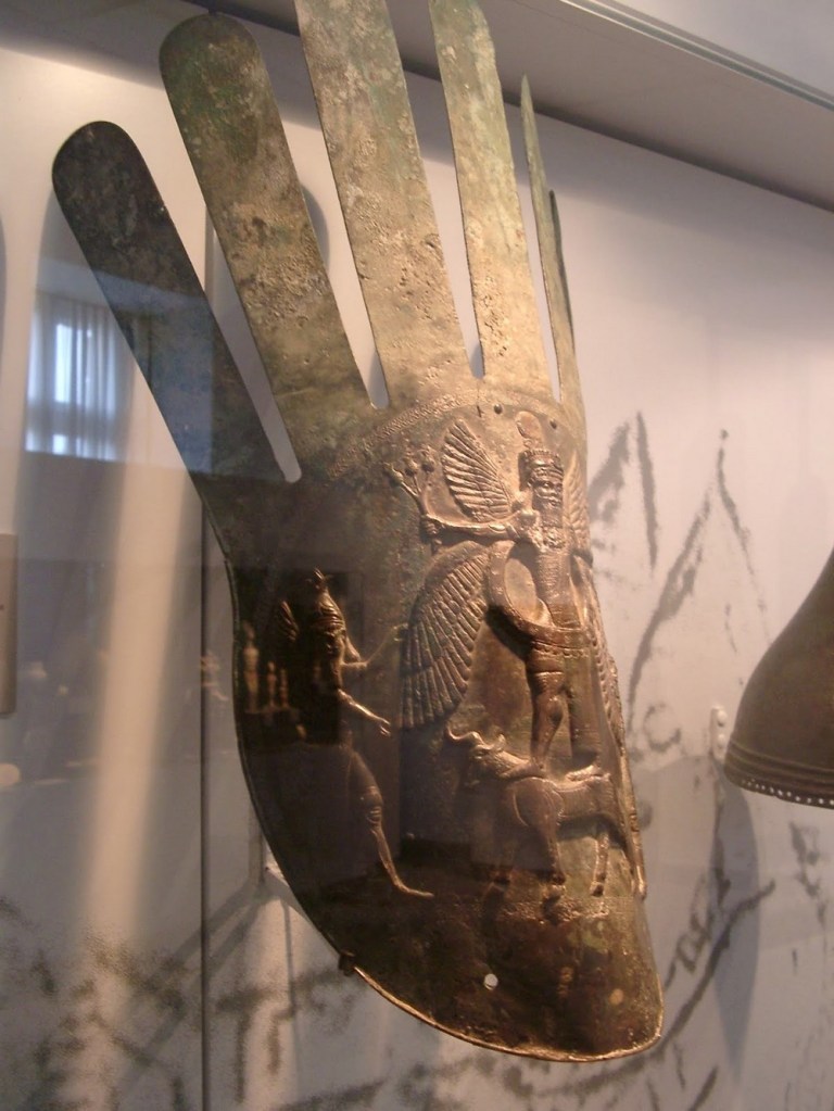
The Urartians worshipped nearly 80 different Gods. But none was as revered as Khaldi (Haldi), the Sky God who helped Urartian kings in war. The Urartians often depicted their Gods with wings, like their rivals to the south, the Assyrians.
The Urartians regularly performed ritual animal sacrifices in open-air sanctuaries.
Photos from 7 to 14
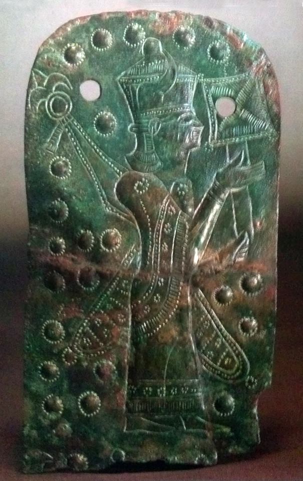
7-Bas Relief of Haldi
Haldi (Khaldi) was the supreme god of the Urartian pantheon, and there was a temple dedicated to him at ancient Erebuni.
Erebuni was the first Urartian fortress constructed north of the Araxes River in the Armenian highlands.
https://www.worldhistory.org/image/7162/bas-relief-of-haldi/
8-Urartian God
http://rubens.anu.edu.au/raider4/europe.0602/germany/karlsruhe/badisches_landesmuseum/archaeology/urartu/index.html
9-Urartu, Eagle Headed Beings
https://armeniaaeterna.weebly.com/the-gods-of-urartu.html
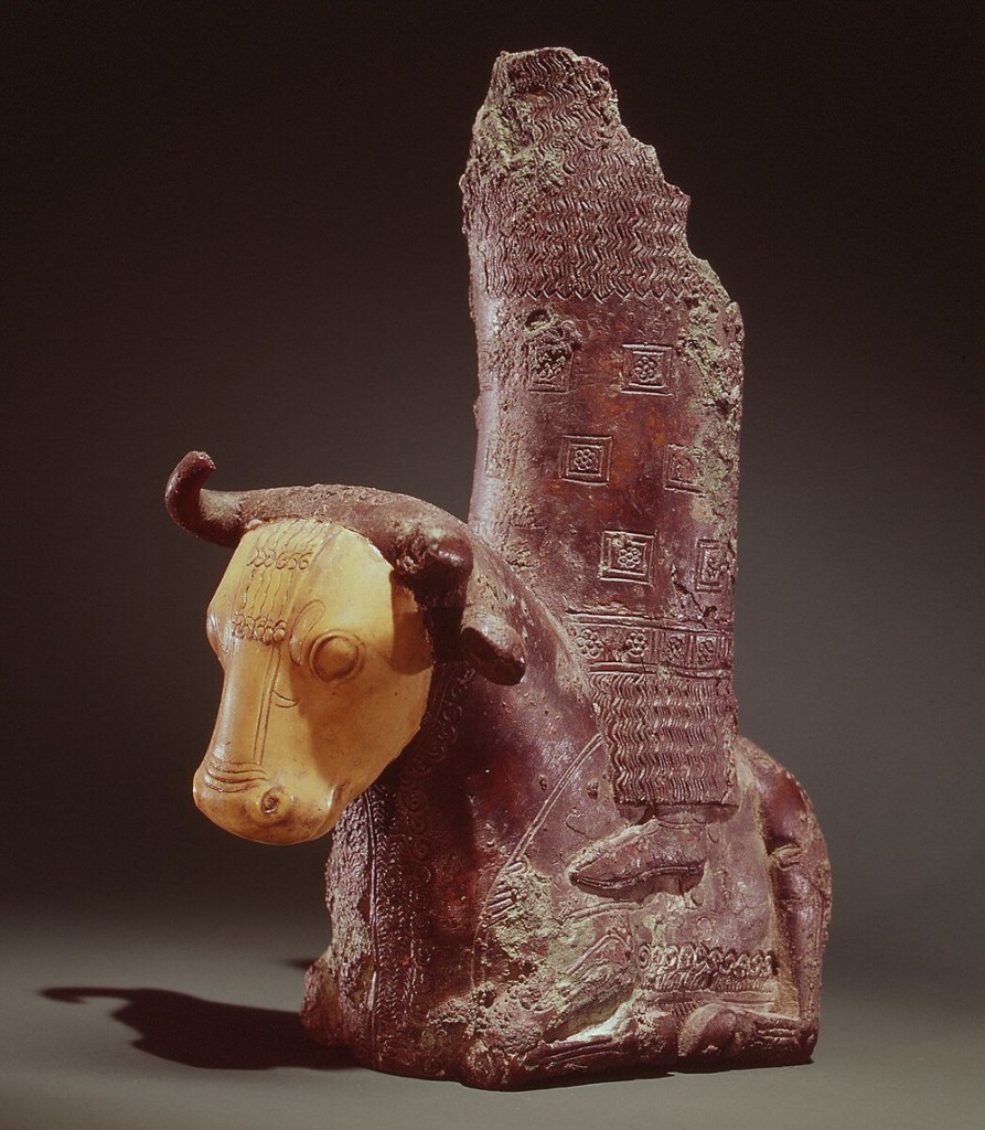
10-Urartian Part of a throne with deity on a bull ca. late 8th–7th century BC
https://www.metmuseum.org/essays/urartu
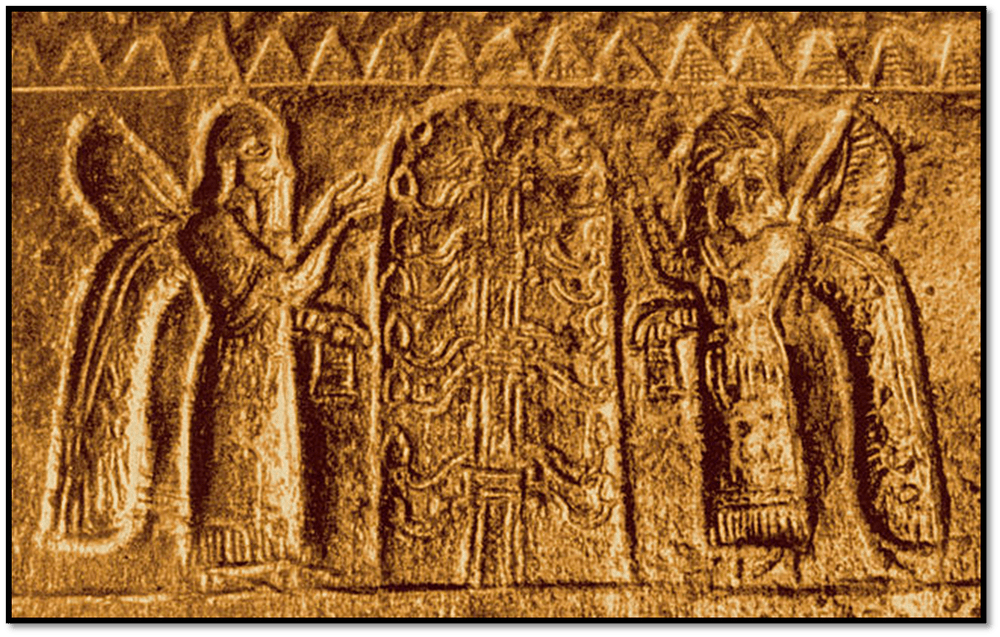
11-Urartian God Khaldi standing on the lion and his wife Arubani, Goddess of Fertility
12-Urartian Goddess
13-Fragment of a bronze helmet from Argishti I’s era. The « tree of life », popular among the ancient societies, is depicted.
The helmet was discovered during the excavations of the fortress Of Teyshebaini on Karmir-Blur (Red Hill) in Armenia.
https://en.wikipedia.org/wiki/Urartu#/media/File:Urartu_Helmet_Fragment_1.jpg
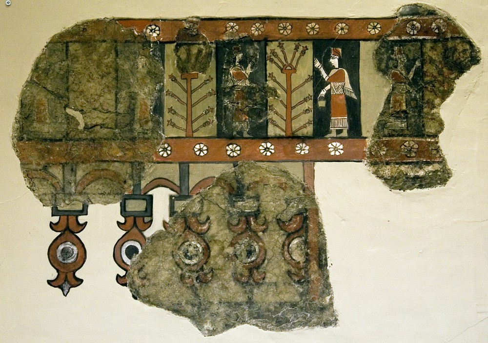
14-Tree of life in Urartian Fresco
https://commons.wikimedia.org/wiki/File:Tree_of_life_in_Urartian_Fresco.jpg
*
-Who were the Horites in the Bible?
https://www.gotquestions.org/Horites.html
*
-Tushpa
https://en.wikipedia.org/wiki/Tushpa
-Urartu Religion – World History Encyclopedia
https://www.worldhistory.org/Urartu_Religion/
-THE GODS OF URARTU
Khaldi/Haldi was the supreme deity of Urartians, the king of gods. The natives of the land called themselves Khaldians after him. All of the kings of Urartu considered themselves as his direct descendants.
Khaldi was the god of victory and war, fertility and agriculture, felicity and family, in short, his many attributes covered the main aspects of life. He also represented the sun and was always portrayed standing on a lion.
https://armeniaaeterna.weebly.com/the-gods-of-urartu.html
-The Goddesses
https://flamingoftherose.com/The-Goddesses
◇─◇
(3)
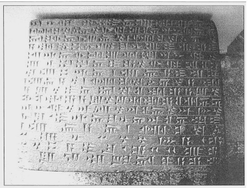
Meher Kapısı inscription (Urartian text)
The Meher Kapısı is a monumental rock carved niche located four kilometres north east of Van Kalesi, the site of the Urartian capital of Tušpa. Inside the niche a cuneiform text was carved, which defines the Urartian pantheon and sets ritual instructions.
The text contains a long list of deities, starting with Ḫaldi. The head of the Urartian pantheon is followed by Teišeba, the weather god, and Šiuini, a solar deity. After the triad of the most important gods worshipped across the Urartian state, the text contains a long list of names, many of which are otherwise unknown deities.
For each listed god there are instructions regarding the type and number of animals to be sacrificed during a yearly ritual. The text also mentions the gods of certain cities, without giving their names, and the gods of the lake and of the valley. Urartu developed from a series of small chiefdoms spread out on the Armenian Plateau, and had its capital established by Sarduri I on the eastern shores of Lake Van during the mid 9th century BCE.
From what today is the modern city of Van, the royal dynasty created by Sarduri ruled until the first half of the 6th century BCE. At one point the main antagonist of the Neo-Assyrian Empire, Urartian territories stretched from Lake Sevan to the southern shore of Lake Urmia, and as far West as the sources of the Euphrates.
Mostly known for their metalwork and their fortifications, Urartians had a well established religion with Ḫaldi at the head of the pantheon. Although most Urartian temples and inscriptions are dedicated to him, the Meher Kapısı inscription shows a more complex picture, with dozens of gods being worshipped across the territories of the ancient state.
https://open.library.ubc.ca/cIRcle/collections/ubccommunityandpartnerspublicati/52387/items/1.0416079
Photo
15-Rock niche Meher Kapisi with offering inscription of king Minua (first half of the 8th century BC), photo: Mirjo Salvini, July 2003
Electronic Corpus of Urartian Texts (eCUT)
https://www.en.ag.geschichte.uni-muenchen.de/research/ecut/index.html
◇─◇
(4)
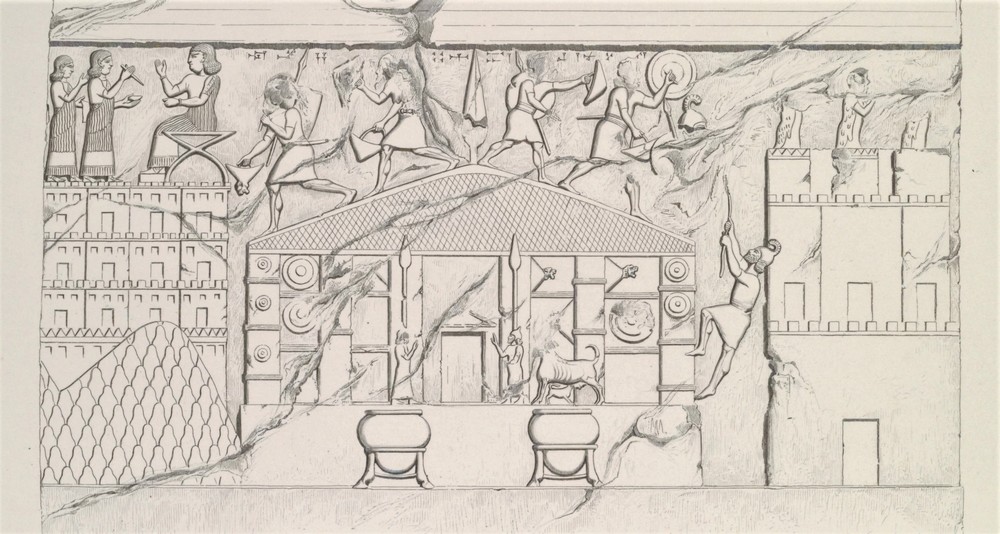
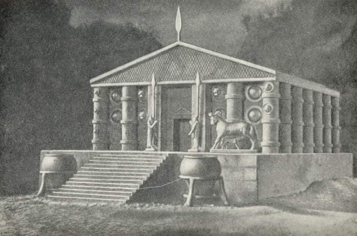
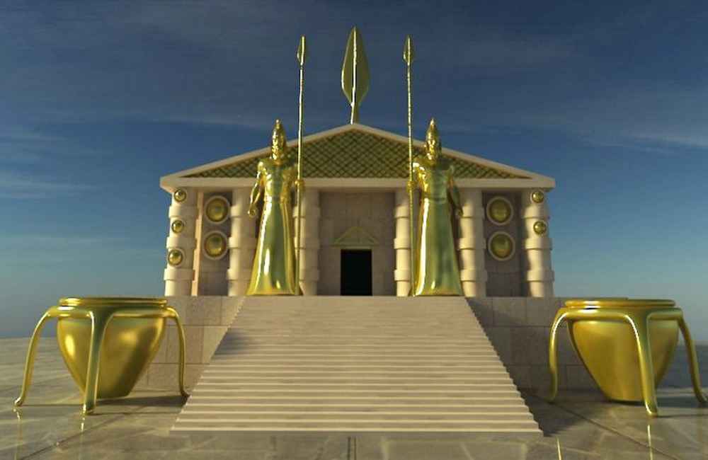
The Musasir Temple of Urartu
Musasir appears in Assyrian texts from the 9th century BC as a small principality in the north of their Kingdom.
Scholars have long been searching for an ancient Temple dedicated to a winged warrior God, Haldi.
Haldi (Khaldi) was one of the three chief deities of Urartu. Of all the Gods of the Urartu pantheon, the most inscriptions are dedicated to him.
It is widely believed that the Temple was built in the late ninth century BC to honor the God Haldi, a winged warrior standing on a lion, and the Goddess Bagbartu in the Iron Age kingdom of Urartu, which considered Haldi its national deity.
In ancient times, Musasir was referred to as the « City of the Raven ». This is interpreted by scholars in various ways.
Some think that the raven could be related to Haldi because Mithra was another face of Haldi in the Roman period, and the raven was one of the symbols of Mithra.
Other archaeologists have proposed City of the Raven got its name because the houses of the city were built on a rocky mountain slope, nesting there like ravens.
The capital city had long been written about, first by an Assyrian king who said it was « The holy city founded in bedrock, » then by a later king who referred to the city’s ruler as a « Mountain dweller, » and its own seal called it « The city of the raven. »
According to ancient texts, Musasir’s location could be in the areas of the archaeological site of Rabat Tepe, located in north-western Iran.
Or perhaps, in the mountainous areas of modern Iraqi Kurdistan towards the present-day town of Rowanduz.
Photos
16-Temple of Mussassir.1
Bas-relief from room XIII of the royal palace of Khorsabad: the sack of the temple of the god Haldi at Musasir by the Assyrian troops, scene from the eighth campaign of Sargon II, 714 BC. Copy of a bas-relief from the palace of Dur-Sharrukin (Khorsabad) by Eugène Flandin, Monuments de Ninive (1849).
https://fr.m.wikipedia.org/wiki/Fichier:Khorsabad_Salle_XIII.Bas-relief_4-_sac_de_Musasir.jpg
16-Temple of Mussassir.2
https://armeniaaeterna.weebly.com/the-gods-of-urartu.html
16-Temple of Mussassir.3
https://armeniaaeterna.weebly.com/the-gods-of-urartu.html
16-Temple of Mussassir Maps.4
-Searching for the Kingdom of Musasir
Musasir was an ancient city of Urartu, attested in Assyrian sources of the 9th and 8th centuries BC.
The city’s location is not known with certainty, although there are a number of hypotheses, all in the general area of 36°N 46°E, in the Zagros south of Lake Urmia.
Urartologist Paul Zimansky speculated that the Urartians (or at least the ruling family) may have emigrated northwest into the Lake Van region from Musasir.
https://www.penn.museum/sites/expedition/searching-for-the-kingdom-of-musasir/
-King Sargon II of Assyria captured the Urartian city of Ardini or Mussassir in 714 BC.
We learn from his rock carvings in Khorsapat, that after this victory and the looting of the temple, King Russa I of Urartu « threw himself on the ground, tore his clothes, and his arms hung limp. He ripped off his headband, pulled out his hair, pounded his chest with both hands, and threw himself flat on his face … » and committed suicide.
To understand King Russa’s extreme reaction to this defeat, one must understand that Mussassir was dedicated to the worship of Khaldi and his wife, Warubayini. It was the holiest city of the kingdom of Urartu.
https://armeniaaeterna.weebly.com/the-gods-of-urartu.html
-The Wall-Paintings of Erebuni
https://ia803208.us.archive.org/34/items/hovhannisyan-1973-erebuni/Hovhannisyan_1973_Erebuni.pdf
-Cultural interaction between Assyria and the Northern Zagros
Part of the city of Musasir depicted on a relief in the palace of Sargon II in Dur-Sharrukin is called by P. Albenda “a four-storied building,” (Albenda 1986:91) and by L. Oppenheim “multistoried buildings.” However, the relief shows the private houses on the slope of a mountain. A similar way of building houses can still be seen in traditional villages in the Zagros.
https://scholarlypublications.universiteitleiden.nl/access/item%3A2855728/view
-Excavations at Tepe Rabat, and Its Ancient Name
https://www.persicaantiqua.ir/article_195529.html
https://www.persicaantiqua.ir/article_195529_e937e62c22b95709643239ce2b20ae95.pdf
-A Preliminary Report of Excavations at Rabat Tepe, Northwestern Iran
https://www.academia.edu/6132426/A_Preliminary_Report_of_Excavations_at_Rabat_Tepe_Northwestern_Iran
◇─◇
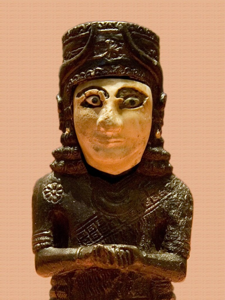
(5)
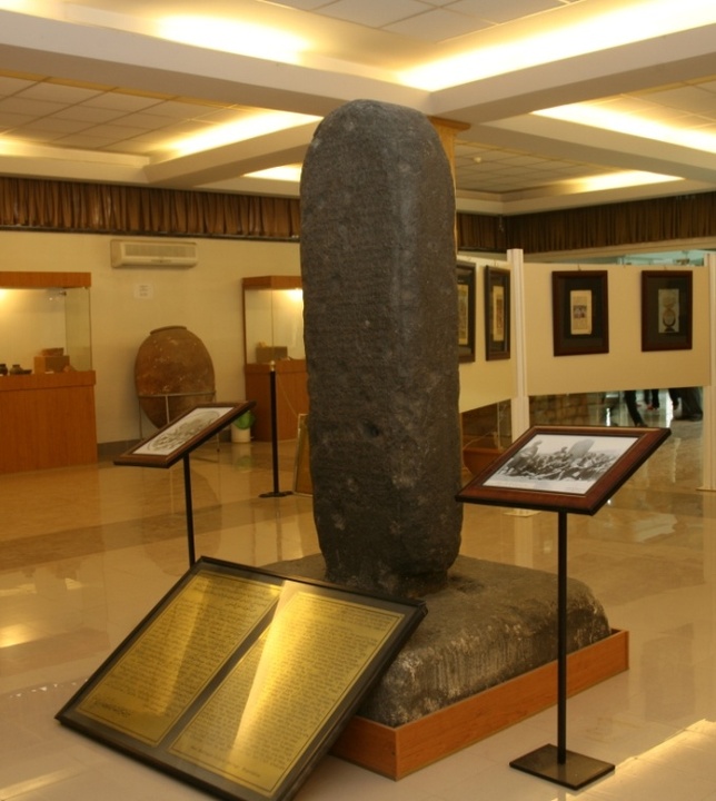
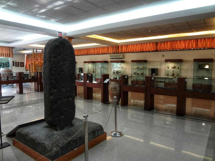
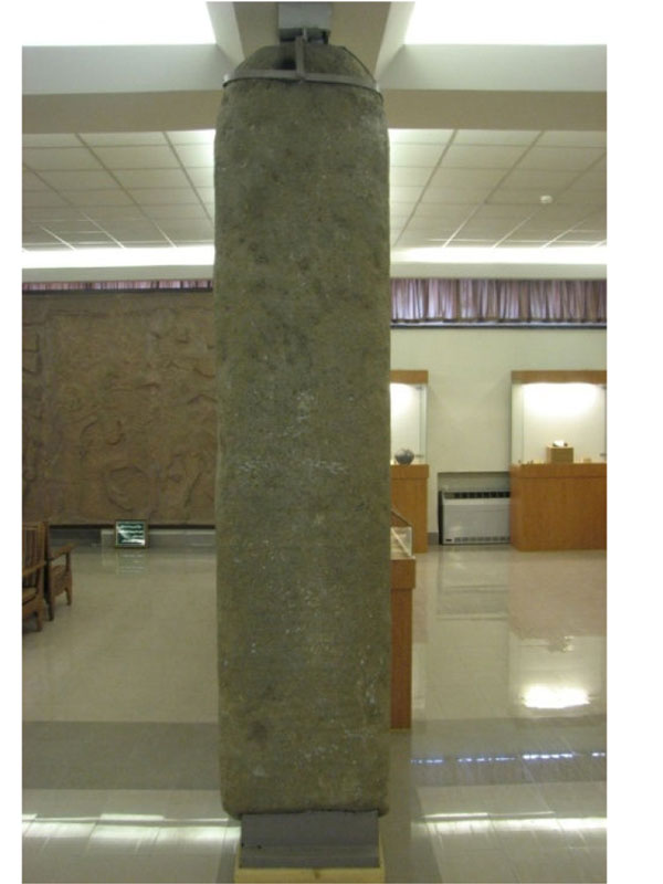
Urartu (Kelashin) Stele, King Ishpuini, 800 BC.
The inscription bears witness to King Ishpuini’s acquisition of the city of Musasir. The bilingual inscription testifies to the linguistic complexity and administrative practices of the Urtetian and Assyrian civilizations during the Iron Age.
The stele was first described by German archaeologist Friedrich Eduard Schulz in 1829, during his trip to Iran, but his research notes were lost when he was murdered by Kurdish bandits.
In 1838, British scientist Henry Crawicke Rawlinson attempted to survey the inscription, but poor weather conditions (-20°C) made the work impractical.
A few years later, another German archaeologist, R. Rosch, attempted to examine the stele, but was murdered along with 38 men from his escort, again all killed by Kurdish bandits.
And in 1893, French archaeologist Jacques de Morgan published a description of the stele, acknowledging that it was written in two languages.
George G. Cameron of the University of Michigan made the first latex print in 1951.
Followed in 1976 by an Italian expedition led by Paolo Emilio Pecorello and Mirjo Salvini, the stele was re-examined.
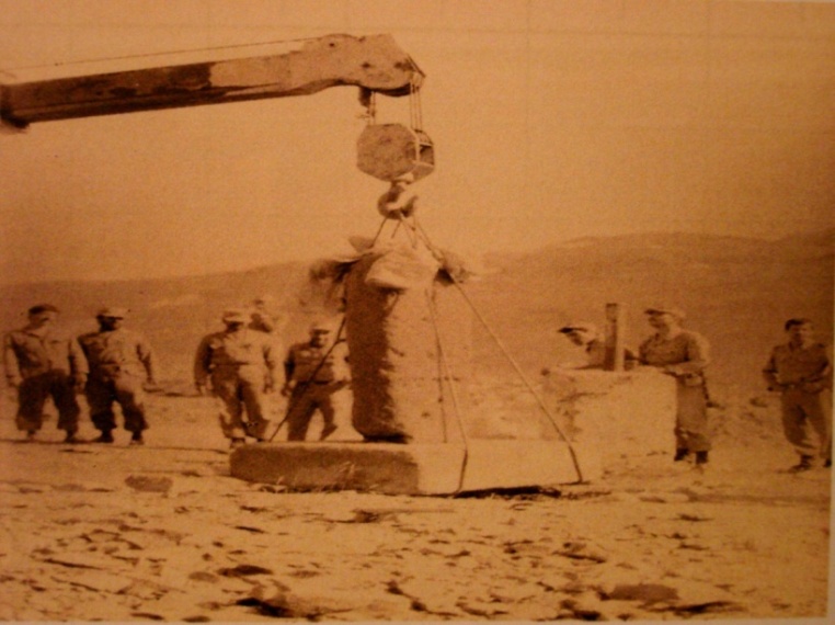
All research was then suspended in 1980 when war broke out between Iran and Iraq. To protect the stele, the Iranian government decided to house it in the Urmia Museum. The stele is still there and can be seen in this museum.
It is only recently that research has re-started.
Research into the inscriptions reveals that the monument was erected by Ishpuinis, king of Urartu, in 800 B.C. The king was returning from conquering the city of Musasir, home to the temple of the war god Haldi, when he crossed the passage of (Kelashin).
One side of the monument is written in Urartu, the other in Assyrian, and tells the story of Musasir’s conquest and the sacrifice made in Haldi’s name. Indeed, King Ishpuini ordered the sacrifice of hundreds of cattle for Hald.
King Ishpuini was so confident of his power that he began to use names signifying his eternal glory, such as (glorious king) and (king of the universe).
Haldi remained the great God of Urartu until Musasir was conquered by the Assyrian king Sargon II in 714 BC.
And sentences inflicted by King Ishpuinis with these words about the Stele:
“Whoever destroys this monument,
he who harms it,
he who breaks it,
he who buries it underground,
he who throws it into the water,
he who tears it down,
he who hides it in the sun,
may the wrath of Haldi be upon him”.
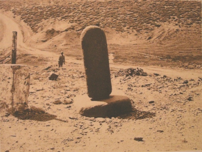
The original location of King Ishpuini’s Urartu Stele was on a much-frequented passageway for various tribes between upper Mesopotamia and the Iranian plateau.
This area was divided by modern borders to create Iraq, created by Great Britain in 1920. And later, in 1932, the modern Kurdistan region of Iraq also emerged.
As a result, (Urartu Stele) has been renamed (Kelashin Stele), the name of the place where the stele was found, which is in the modern Kurdistan region of Iraq, near the Kelashin Pass on the border with Iran.
Photos
17-Urartu Stele, King Ishpuini, 800 BC., Iran.1
17-Urartu Stele, King Ishpuini, 800 BC., Iran.2
17-Urartu Stele, King Ishpuini, 800 BC., Iran.3
17-Urartu Stele, King Ishpuini, 800 BC., Iran.4
17-Urartu Stele, King Ishpuini, 800 BC., Iran.5
-The Inscription of Ishpuini and Meinua at Qalatgah, Iran. Qalatgah An Urartian Site in Northwestern Iran.
https://www.penn.museum/sites/expedition/qalatgah/
◇─◇


(6)
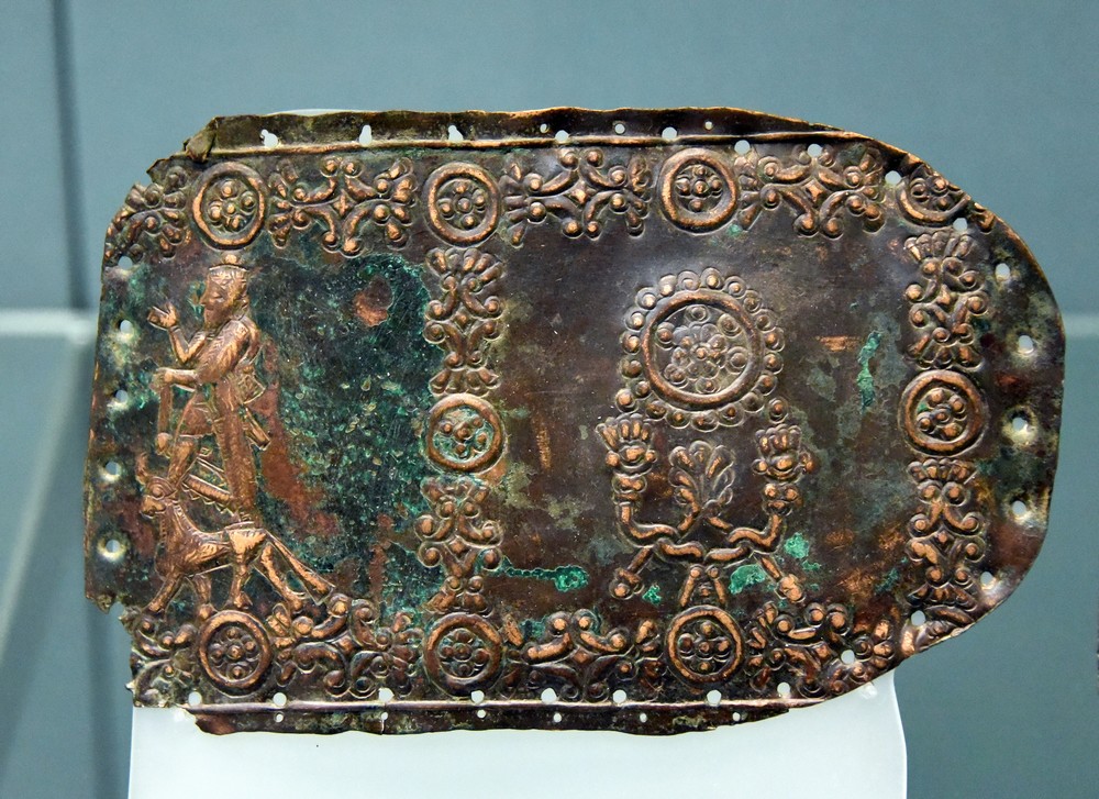
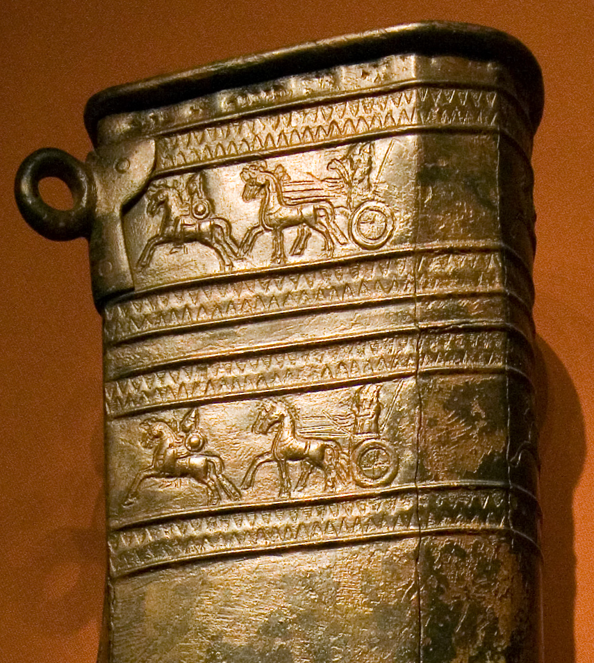
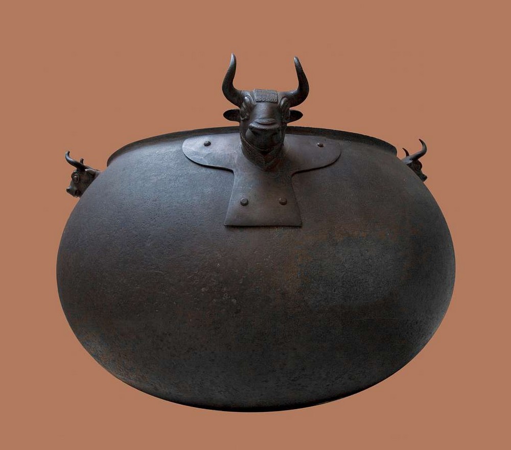
The Kingdom of Urartu was rich in bronze and iron resources. The people of Urartu were renowned as metallurgists by their surrounding neighbors.
Photos from 18 to 23
18-Silver Necklace Urartian 8th to 7th centuries BC
https://www.miho.jp/booth/html/artcon/00000921e.htm
19-Urartian Fragment from a Bronze Belt 7th century BC
(The British Museum, London).
20-Urartu Decorated Quiver 9th-6th century BC
A bronze quiver of the Urartu civilization (9th-6th century BCE) from Teishebaini (Kamir-Blur, Armenia). It is inscribed with the name of King Sarduri II (r. c. 760-743 BCE)
(Hermitage Museum, Saint Petersburg)
21-Urartian cauldron with bull heads found in Van Armenia.
22-Detail of a bronze throne of Urartian kings
23-AN URARTIAN BRONZE HELMET, CIRCA 9TH-7TH CENTURY B.C.
https://www.orientalartauctions.com/object/art99938-an-urartian-bronze-helmet-circa-9th-7th-century-b-c
*
(See more photos of other Urartu objects)
-Urartian Bronze Fitting with Bird, Boar and Hare Motifs, 900 BCE – 600 BCE
https://barakatgallery.eu/artworks/categories/979/74547-urartian-bronze-fitting-with-bird-boar-and-hare-900-bce-600-bce/
-Urartian Bronze Belt, 740 BCE – 640 BCE
https://barakatgallery.eu/artworks/categories/979/60182-urartian-bronze-belt-740-bce-640-bce/
-Urartian Jewellery Collection
https://www.rhm.org.tr/en/event/rezan-has-museum-urartian-jewellery-collection/
-62 Urartu Images: PICRYL – Public Domain Media Search Engine Public Domain Search
https://picryl.com/topics/urartu
-Urartu Art
The art produced by the Urartu civilization, which flourished in ancient Armenia, eastern Turkey, and northwestern Iran from the 9th to 6th century BCE, is best seen in bronze figurines of deities, bronze cauldrons with animal and goddess head decorations, and vibrant wall paintings. A mix of Mesopotamian and indigenous subjects coupled with outstanding craft skills make the artworks of Urartu some of the star attractions in the Near Eastern collections of museums worldwide from London to Saint Petersburg.
https://www.worldhistory.org/Urartu_Art/
-Urartian Art Image
https://garystockbridge617.getarchive.net/amp/topics/urartian+art
-Urartians had glorious achievements in metalworking from about 9th to 6th B.C.
Their metal objects have been decorated by different figures and motifs including animals, plants and mythical creatures.
https://www.persicaantiqua.ir/article_133723_45876ccd1ca5962253522c0e44205e2c.pdf
◇─◇
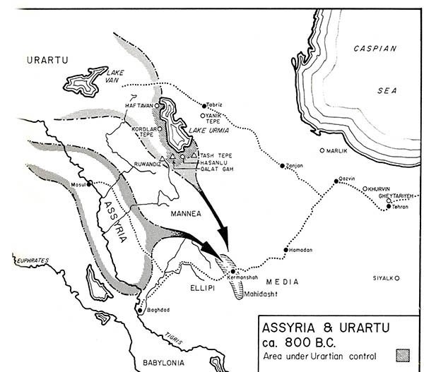
(7)
The end of Urartu
The Urartians held on to their kingdom for around 250 years, facing and resisting pressure from the Assyrians to the south, and the *Cimmerians and *Scythians to the north.
But the process of Urartu’s demise was carried out by the *Medes in 585 BC. The Medes built the Mede Kingdom (Mada in Old Persian, meaning “Country”, “Land”), which was located between western and northern Iran.
On the other hand, Urartu was completely absorbed when Cyrus the Great took power in 550 BC, establishing the Iranian/Persian, Achaemenid Empire, which in turn absorbed the Mede Kingdom. The Medes had a great religious influence on the peoples of the Achaemenid Empire.
*The Cimmerians and Scythians are groups related to the Iranian family who, according to their territorial movements, united with other ethnic groups, creating other sub-groups that populated parts of the West.
*In the Bible, the Medes are described as the descendants of Noah. Furthermore, the three Magi in the Bible are descended from the priestly caste of the Medes.
Photo
24-Assyria-Urartur, cicra 800 BC.
-The Last Days of Urartu’s Rule, Historical Knowledge and Archaeological Evidenc
https://jhss.ut.ac.ir/article_94751.html?lang=en
-The Median “Empire”, the End of Urartu
http://www.achemenet.com/pdf/in-press/Rollinger-Iran.pdf
-The Median “Empire”, the End of Urartu and Cyrus’ the Great Campaign in 547 BC
https://www.academia.edu/11349598/R_Rollinger_The_Median_Empire_the_End_of_Urartu_and_Cyrus_the_Great_Campaign_in_547_BC_Nabonidus_Chronicle_II_16_In_Ancient_West_and_East_7_2009_49_63
-The Medes were an ancient Iranian people who spoke Median and inhabited Media, an area spanning western to northern Iran.
https://history-maps.com/story/History-of-Iran/event/Medes
◇─◇

(8)
The beginning of Armenia: Inscription of Behistun in Kermanshah, Iran – (Inscribed by UNESCO in 2006)
After Cyrus the Great took power in 550 BC, establishing the Iranian/Persian, Achaemenid Empire, the name Urartu will gradually disappear. And it was under Darius I, who ruled the Achaemenid Empire from 521 to 486 BC, that the name Urartu was replaced by Armina in Old Persian.
The whole region of Armina/Armenia was one of the twenty *Satrapies of the vast Achaemenid Empire.
History will show that from the Iranian/Persian Achaemenid Empire (521-331 BC), followed by other Iranian Empires (Parthian Empire 247 BC-224 AD), then (Sassanid Empire 224 AD-651 AD), Armenia was completely integrated into the Iranian world.
At the same time, Armenia also made its way to independence and continued to shape its own culture, but Armenia remained an Iranian province until the Russo-Persian wars. ( Russo-Persian Wars: https://en.wikipedia.org/wiki/Russo-Persian_Wars ).
After the Russo-Persian War of 1804-13, Iran had to forcibly cede the Eastern Armenia to Russia, the Karabakh Khanate, whose capital is Shusha and which includes the present-day Armenian province of Syunik (Zangezur).
Then, after the Russo-Persian war of 1826-28, Iran had to forcibly cede the western Armenia to Russia, the khanates of Erivan (Yerevan) and Nakhicevan. The Khanate of Nakhchivan also included the present-day Armenian province of Vayots Dzor.
Ties between the two countries remain strong to this day. Iran is home of the oldest Armenian churches. ( Armenian Monastic Ensembles of Iran: https://whc.unesco.org/en/list/1262/ ).
Photo
25-Persian-Empire (Iran-Persia)
*In the Achaemenid Empire (560-333), a satrape (a word derived from an Old Persian word meaning “protector of the province”) was the governor of a satrapy, the empire’s main administrative division.
The satrape is the king’s direct representative in a province, where he exercises all royal prerogatives.
After the conquest of the Persian Empire by the Macedonian King Alexander (circa 330 BC), the satrapy system was maintained and continued in the Hellenistic empire of the Seleucids.
The word “satrape” has also found its way into the French language, without any specific reference to the history of the Persian Empire.
Although the first large-scale use of satrapies, or provinces, dates back to the creation of the Achaemenid Empire under Cyrus the Great, from around 530 BC, provincial organization actually originated in the Mede period from at least 648 BC.
-A List of the Satrapies of the Achaemenid Persians
https://www.thoughtco.com/satrapies-of-the-achaemenid-persians-120229
-ACHAEMENID SATRAPIES
https://www.iranicaonline.org/articles/achaemenid-satrapies
-Satraps (Old Persian khšaçapâvâ): the governors of the satrapies (provinces) of the ancient Achaemenid Empire.
https://www.livius.org/articles/concept/satraps-and-satrapies/
-From the kingdom of Urartu to the Achaemenid period in the territory of Ancient Armenia: characterization of a transition period from archaeological and historical sources
The theme of this work is the transitional period between the kingdom of Urartu and the domination of Achaemenid Iran (7th -6th centuries BC).
https://theses.hal.science/tel-04166881
-ARMENIA and IRAN i. Armina, Achaemenid province
https://iranicaonline.org/articles/armenia-i
-« THE FALL OF URARTU AND THE RISE OF ARMENIA, »
https://www.academia.edu/37612879/T._Daryaee_THE_FALL_OF_URARTU_AND_THE_RISE_OF_ARMENIA
-Toponyms Armenia and Urartu
https://www.peopleofar.com/tag/nairi-kingdom/
-The ancient origins of the Armenian people.
https://www.vazgentheurartian.com/armenian-history
-The main God of Ararat-Urartu mythology of Armenian country
https://yhm.am/archives/9804?lang=en
The beginning of Armenia: Inscription of Behistun in Kermanshah, Iran – (Inscribed by UNESCO in 2006)
After Cyrus the Great took power in 550 BC, establishing the Iranian/Persian, Achaemenid Empire, the name Urartu will gradually disappear. And it was under Darius I, who ruled the Achaemenid Empire from 521 to 486 BC, that the name Urartu was replaced by Armina in Old Persian.
The whole region of Armina/Armenia was one of the twenty *Satrapies of the vast Achaemenid Empire.
History will show that from the Iranian/Persian Achaemenid Empire (521-331 BC), followed by other Iranian Empires (Parthian Empire 247 BC-224 AD), then (Sassanid Empire 224 AD-651 AD), Armenia was completely integrated into the Iranian world.
At the same time, Armenia also made its way to independence and continued to shape its own culture, but Armenia remained an Iranian province until the Russo-Persian wars.
After the Russo-Persian War of 1804-13, Iran had to forcibly cede the Eastern Armenia to Russia, the Karabakh Khanate, whose capital is Shusha and which includes the present-day Armenian province of Syunik (Zangezur).
Then, after the Russo-Persian war of 1826-28, Iran had to forcibly cede the western Armenia to Russia, the khanates of Erivan (Yerevan) and Nakhicevan. The Khanate of Nakhchivan also included the present-day Armenian province of Vayots Dzor.
Ties between the two countries remain strong to this day. Iran is home of the oldest Armenian churches. (Armenian Monastic Ensembles of Iran: https://whc.unesco.org/en/list/1262/
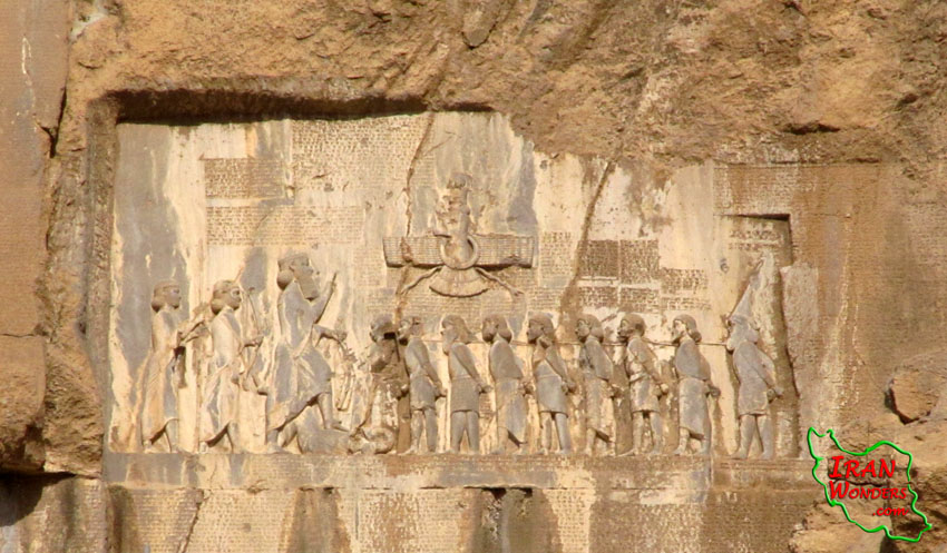
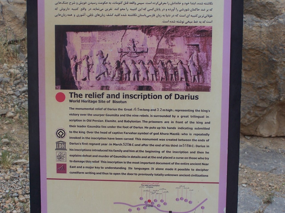
The name “Armenia” appears for the first time in the cuneiform inscription at Behistun. Behistun was inscribed on UNESCO’s World Heritage List in 2006.
The Behistun inscription is a monumental inscription describing the conquests of Darius I in three languages: Old Persian, Elamite and Akkadian. These three languages were a common language between peoples.
The bas-relief with the inscription stands some 60 metres high and measures 25 by 15 metres.
The relief and inscription were placed near a major road linking the Iranian plateau to the lowlands of Mesopotamia, so that travelers could see them as they moved between the Empire’s most important regions.
The Behistun inscription is to cuneiform writing what the Rosetta Stone is to Egyptian hieroglyphics: the most crucial document in the deciphering of this script.
Sculpted by order of the Achaemenid King Darius I in 520 BC.
“I am Darius,” the Behistun Inscription begins, “the Great King, the King of Kings.” In Old Persian, the cuneiform reads: Dârayavauš xšâyathiya vazraka xšâyathiya xšâyathiy.
King Darius says: These are the countries which are subject unto me, and by the grace of *Ahuramazda[,] I became king of them:
Persia, Elam, Babylonia, Assyria, Arabia, Egypt, the countries by the sea, Lydia, the Greeks, Media, Armenia, Cappadocia, Parthia, Drangiana, Aria, Chorasmia, Bactria, Sogdia, Gandara, Scythia, Sattagydia, Arachosia and Maka; twenty-three lands in all.
*Ahura Mazda (from the Old Persian Auramazdâ), meaning “Wise Lord”, was the Supreme God of the ancient Iranian Mazdean religion, and more particularly of Zoroastrianism.
-The four phases of the Mazdean religion
https://www.college-de-france.fr/en/agenda/guest-lecturer/the-four-phases-of-the-mazdean-religion
-All You Need to Know about Zoroastrianism
https://aspirantum.com/blog/all-about-zoroastrianism
Photos
26-Bisotun World Heritage Site of Kermanshah Iran
https://www.iranwonders.com/fa/articles-fa/20-behist
(See more photos)
-Behistun Inscription
https://vici.org/vici/24008/?lang=nl
-Bisotun – UNESCO
The inscription at Bisotun (meaning “place of gods”), which is about 15 m high by 25 m wide, was created on the orders of King Darius I in 521 BC.
Much of it celebrates his victories over numerous pretenders to the Persian Empire’s throne. The inscription was written in three different cuneiform script languages: Old Persian, Elamite, and Babylonian. Once deciphered in the 19th century, it opened the door to previously unknown aspects of ancient civilizations. In that sense, the inscription at Bisotun has had a value for Assyriology comparable to that of the Rosetta Stone for Egyptology.
https://whc.unesco.org/en/list/1222/
-The Bisotun World Heritage Site of Kermanshah was inhabited by Neanderthals on the basis of archaeological excavations from the Paleolithic period, and from the historical period, on the one hand, because of its geographical situation and its location on the route of the royal road that linked the Iranian plateau to Mesopotamia, on the other hand, in terms of the important position that Bisotun Mountain had in ancient Iranian beliefs, with various monuments from the Achaemenid, Parthian, Sassanid, Islamic and contemporary centuries being built around it.
This site, once known as the Zagros Gate, contains antiquities from prehistory and history.
https://www.iranwonders.com/fa/articles-fa/20-behist
-In the trilingual inscription by the Achaemenid King Darius at Bisutun, the twentieth satrapy is named Urašṭu in the Babylonian text and Armina (Schmitt 1980) in the Persian one.
This is the earliest mention of the country and the ethnos of Armenia and goes back to the year 521 BCE (Malbran-Labat 1994, §6, 23, 24).
This correspondence enables us to consider the history of Urartu as the beginning of the history of Armenia.
https://www.mprl-series.mpg.de/media/proceedings/7/16/proc7chap14.pdf
-Bīsotūn, ‘Urartians’ and ‘Armenians’ of the Achaemenid Texts
A new analysis of the Bīsotūn (Behistun) inscription and evidence from other texts of the Achaemenid period supports the developing conceptualization of Biainili-Urartu as an empire inhabited by different peoples that spoke a variety of languages.
The exonyms Urartu, ‘Urartians’ and Armina, ‘Armenians’ cannot be interpreted as ethnic terms. Those rather were synonymic geopolitical and demographic concepts used by foreigners until the end of the fifth century BCE.
It is highly probable that the peoples inhabiting the Iranian Plateau used the names Armina, or Harminu to define the empire of Biainili at the same time when the peoples of Syro-Mesopotamia called it Urartu, no later than in the seventh century BCE and maybe earlier.
However, being synonymous, neither Urartu nor Armina had signified one and the same political and sociocultural unit.
Urartu was a geographic and demographic identifier of the Armenian Highland and its population during the Early Iron Age, of the following empire of Biainili, and of the subsequent periods of domination of that territory by the Median polity and the Achaemenid Empire.
Emerging in the times of Biainili, the exonym Armina continues its existence to the present in the exonymic name Armenia.
https://www.archaeopress.com/Archaeopress/DMS/01395710731745869652C7160519F1A3/9781784919436-sample.pdf
-The monumental relief of Darius I, King of Persia, representing the king’s victory over the usurper Gaumāta and the nine rebels (cf. ii, above), is surrounded by a great trilingual inscription in Old Persian (text DB in Kent, Old Persian), Elamite, and Babylonian.
https://www.iranicaonline.org/articles/bisotun-iii
-Inscription of Darius the Great in Bistun
https://www.heritageinstitute.com/zoroastrianism/behistun/index.htm
-THE OLDEST PHOTO OF DARIUS’S INSCRIPTION IN BEHISTUN: A NEW DOCUMENT
https://cidoc.mini.icom.museum/wp-content/uploads/sites/6/2020/02/CIDOC2018_paper_138.pdf
-A New Edition of the Elamite Version of the Behistun Inscription (I)
https://cdli.mpiwg-berlin.mpg.de/articles/cdlb/2017-3
◇─◇


(9)
Remains of the Urartian archeologique sites outside of Iran
Urartu was located on the Armenian mountain plateau, between Mesopotamia, the Iranian Plateau and the Caucasus Mountains.
Its center was the Armenian plateau between lakes Van, Urmia and Sevan.
Nowadays, most remains of Urartian settlements are found between the four lakes Çildir and Van in Turkey, Urmia in Iran, and Sevan in Armenia, with a sparser extension westward to the Euphrates River.
Photos
27-Armenian Highlands (Wikipedia)
https://en.wikipedia.org/wiki/Armenian_highlands
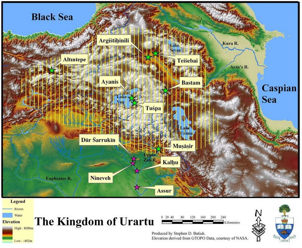
28-Description: Map of the Kingdom of Urartu and major sites
Credit: Stephen Batiuk, January 2006
https://www.asor.org/resources/photo-collection/maps/mid000036
29-Urartu_forteresses.svg
https://fr.m.wikipedia.org/wiki/Fichier:Urartu_forteresses.svg
« The Kingdom of Urartu coalesced in the late ninth century BCE and for two centuries embraced an extensive territory in what is now eastern Turkey, northwestern Iran, and Armenia. »
Mapping Ancient Urartu
An Interactive History of Urartian Archaeology and Decipherment, 1826–1996
https://storymaps.arcgis.com/stories/7c8f30b861084bd7a59d50de908b7430
-Tushpa/Van Fortress, the Mound and the Old City of Van
https://whc.unesco.org/en/tentativelists/6114/
-Urartu
https://www.urartians.com.tr/icerik/35/history-and-geography.html
-Archaeology and History of Urartu (Biainili)
https://www.jstor.org/stable/j.ctv2crj2n5
-BIAINILI-URARTU (93 pages)
https://www.ucl.ac.uk/sargon/downloads/radner_acta_iranica_51_2012.pdf
-URARTIAN ART AND ARTIFACTS
https://iranianstudiesnews.ir/wp-content/uploads/2024/04/Azarpay_1968_Urartian_Art_Artifacts.pdf
-URARTIAN GARDENS
https://belleten.gov.tr/tam-metin-pdf/2553/eng
-Urartian stylisation
https://www.armarch.net/en/encyclopedia/style-urartian-stylisation
◇─◇
URARTU IN IRAN
(From 10 to 21, Table of contents with photos, texts and links)
10-URARTU archaeological sites in Iran
11-The Kingdom of Urartu and the Lake Urmia in Iran
12-On the shores of Lake Urmia remains of the first stage of the Koura-Araxes culture (3500–2200 BC)
13-Lake Urmia is located in the Iranian province of Azerbaijan
14-Historic Urartian village in Chors, Iran
15-Urartu fortress of Bastam, Iran
16-Urartu Castle in Qoban, Iran
17-Urartu Bari Castle, Urmia Lake Iran
18-Urartuian catacombs (858 – 585 BC)
19-Urartu cuneiform inscriptions in Iran
20-Urartian Bulla from Ziwiye in the northwestern of Iran
21-Bronze Bracelet with Urartian Inscription from Toul, Gilan, Iran
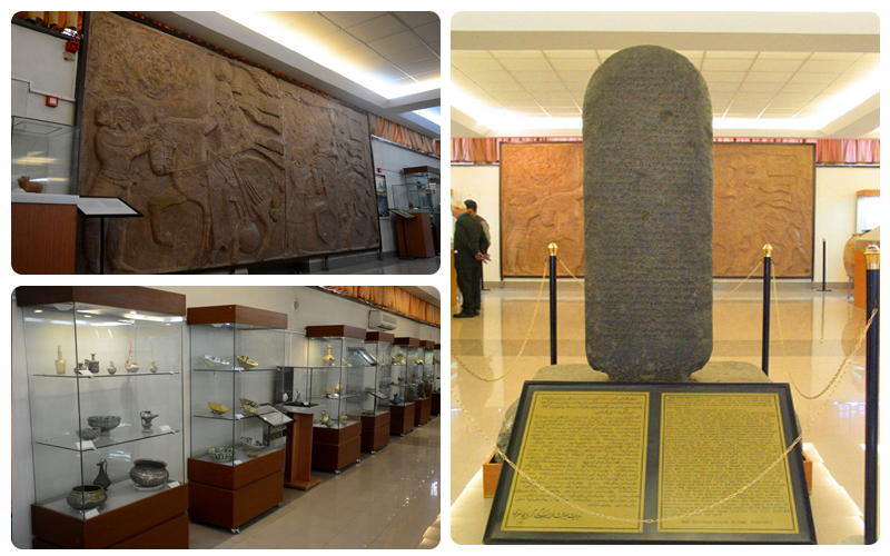
(10)
URARTU archaeological sites in Iran
Urartu was located on the Armenian Plateau, between Mesopotamia, the Iranian Plateau and the Caucasus Mountains.
Today, Urartu’s archaeological sites are located partly in Armenia, partly in Iran and partly in Turkey.
There are currently at least 80 Urartian sites listed in the Iranian province of Azerbaijan.
Some of Urartu’s archaeological sites can be visited, and the Urmia museum has several Urartian artefacts on display.
Urmia museum is a must-visit destination for history enthusiasts eager to explore the city’s rich past.
The museum boasts a vast collection of objects spanning Prehistory, Antiquity and the Muslim era, including pottery, coins, manuscripts and textiles.
The museum features artefacts from Urartian civilization, as well as exhibitions showcasing the cultural and artistic achievements of the various dynasties that shaped Urmia.
There is also a section devoted to the region’s Assyrian and Christian heritage.
-Urmia Museum
https://epiciran.com/place/urmia-museum/
*
There’s also the museum at Mianeh in the Iranian province of East Azerbaijan, which exhibits objects from the Urartu era.
Mianeh (Persian: ميانه) also Romanized as Meyāneh, Miane, Miyāna, Meyaneh, and Mīyaneh) is a city and capital of Mianeh County, East Azerbaijan Province, Iran.
It is the fourth most populous city in East Azerbaijan province. Mianeh is situated in a valley, approximately 439 kilometres (273 mi) northwest of Tehran and approximately 187 kilometres (116 mi) southeast of East Azerbaijan’s largest city and capital, Tabriz.
The original name of the city is Miyanej, but it is often referred to as Garmrood. Mianeh is one of the oldest towns in the region.
Its foundations date back to 720 BC. The city was an economic and cultural crossroads for many centuries.
-Mianeh
https://mapcarta.com/12593842
-Video of the Museum in Mianeh
https://www.chtn.ir/news/14000309860176/%D9%85%D9%88%D8%B2%D9%87-%D9%85%DB%8C%D8%A7%D9%86%D9%87-%D8%AA%D8%A7%D8%B1%DB%8C%D8%AE%DB%8C-%D8%A8%D9%87-%D9%82%D8%AF%D9%85%D8%AA-%D9%85%D8%A7%D8%AF%D9%87%D8%A7
◇─◇
(11)
The Kingdom of Urartu and the Lake Urmia in Iran
On the shores of Lake Urmia, traces of Neolithic cultures dating back to over 7000 BC have been discovered.
We can also mention the Geoy Tapeh archaeological site located just 7 kilometers southeast of Lake Urmia, which demonstrates that this area was continuously occupied from the 4th millennium BC to 1200 BC.
Remains of the first stage of the Koura-Araxes culture (ca. 3500–2200 BC) have also been found in this area.
It’s a region rich in archaeology and history, and research continues to this day.
Urmia (in Persian Daryācheh-ye Orumieh) has been of great importance in Iranian history, its historical significance deriving from its strategic position along the trade routes linking Greater Iran, Anatolia and the Caucasus and its role as a melting pot of diverse cultures, religions and traditions.
In ancient times, the shores of Lake Urmia were known as Gilzan, until the region was invaded by the Assyrians and the lake was renamed Urmia, as early as the 9th century BC.
The Assyrian name “Urmia” means “City of Water” (Ur = City and mia = water).
Gilzan appears to have been an independent Kingdom before being conquered and transformed into a vassal state of the Assyrian Empire. Over time, its integration under Assyrian control deepened and it was fully absorbed into the Empire during the reign of Sargon II at the end of the 8th century BC. After this period, the name Gilzan disappeared from history.
Lake Urmia was once the second largest salt lake in the world. The lake has been recognized by UNESCO as a biosphere reserve and Ramsar wetland.
The Convention on Wetlands, known as the « Ramsar Convention », was signed in Ramsar (Iran) in 1971.
This intergovernmental treaty provides a framework for national action and international cooperation for the conservation and wise use of wetlands. This convention results in the designation of wetlands of international importance.
Lake Urmia was the largest lake inside Iran, and the second biggest salt lake of the world.
Unfortunately, Lake Urmia has been shrinking in size year after year.
To develop its agriculture and food self-sufficiency, the region has drawn heavily on the rivers that feed the lake, with dramatic consequences. Climate change has also accelerated the drying-up of the lake.
Plans are being made to find solutions.
Photos
30-Lake Urmia in Iran
The highs and lows of Lake Urmia, Iran
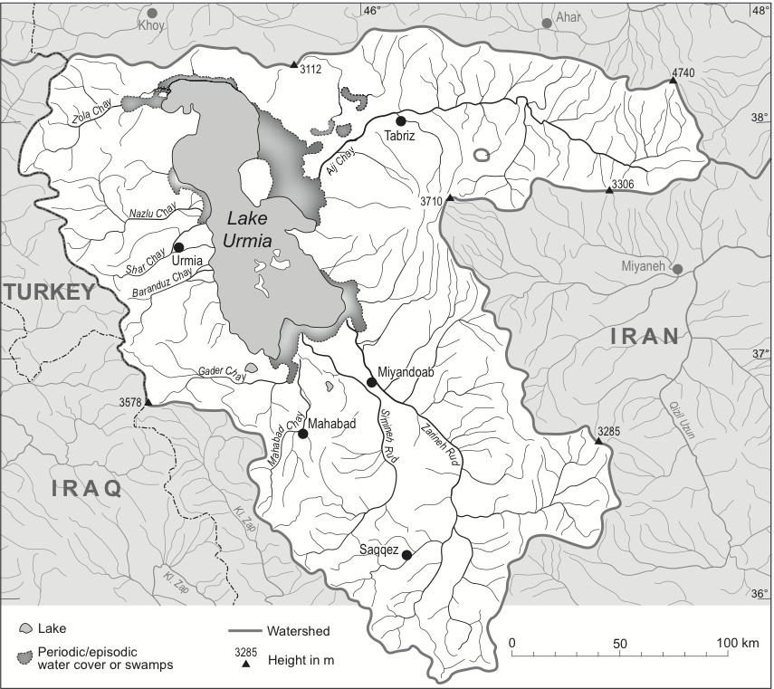
Urmia Lake is a large oligotrophic and extremely hypersaline lake located in Iran. It is described by Encyclopædia Britannica in the following words: « The lake lies in the bottom of the large central depression of the Azerbaijan region in northwestern Iran, at an elevation of 1275 m above sea level. The basin is surrounded by mountains in the west and north, by plateaus in the south, and by plateaus and volcanic cones in the east. The lake is about 140 km long and 40 to 55 km wide, with a maximum depth of 16 m. In its southern portion there is a cluster of about 50 tiny islands. The shoreline varies with the lake level; when the water is high, it extends into large salt marshes to the east and south.
The governing factor of Lake Urmia’s hydrography is its lack of an outlet. It forms the dead end of a large drainage system that covers an area of about 52 000 km² and is subject to great seasonal variation. The main affluents are the Talkheh (Ājī) River in the northeast, which gathers the melted snows from the Sabalān and Sahand massifs, and the twin rivers Zarīneh (Jagātu) and Sīmīneh (Tatavi) in the south. »
https://www.sentinelvision.eu/gallery/html/8ecafc543b69493687d1be4006c1ac49
31-The Kingdom of Urartu in North-Western Iran (Ninth–Seventh Century B.C.E)
https://link.springer.com/chapter/10.1007/978-3-030-41776-5_2
32-Urmia-Lake-fig1
https://www.researchgate.net/figure/Lake-Urmia-and-its-catchment-Urmia-Lake-Hydrography-and-catchment-area-of-Lake-Urmia_fig1_302994508
-Urmia on the map of Iran
https://mapcarta.com/Urmia
-Lake Urmia, northwest Iran, it is by excavating at the bottom of this salt lake that researchers have been able to retrace 200,000 years of history of the vegetation and climate of the Near East. Thanks to the pollen contained in two sediment cores of 100 meters each, taken during the construction of a bridge in 2000 and kept since then at the University of Tehran, the scientists were able to discover what types of trees and plants succeeded each other in the region, and deduced the evolution of the climate.
https://images.cnrs.fr/photo/20090001_0003
-30,000 Years of the southwestern Lake Urmia (Iran) paleoenvironmental evolution inferred from mineralogical indicators from lake and watershed sediments
https://www.sciencedirect.com/science/article/abs/pii/S1367912022003182
-Conditions at Lake Urmia shed Light on Palaeozoic Environments
https://blog.everythingdinosaur.com/blog/_archives/2013/10/03/conditions-at-lake-urmia-shed-light-on-palaeozoic-environments.html
-The Lake Urmia region has a wealth of archaeological sites that were home to some of the most advanced Neolithic communities known.
Archaeological excavations of settlements in the Lake Urmia area have found artefacts that date from the Neolithic (New Stone) age, that is, from about 7,000 BCE. A number of these settlements were destroyed in the Iron Age around 800 BCE, a dating that coincides with records of devastating Assyrian raids in the region.
https://www.heritageinstitute.com/zoroastrianism/urmia/index.htm
-Neolithic Dynamics across Lake Urmia
https://iranhighlands.com/neolithic-dynamics-across-lake-urmia/
-Prehistoric of Urmia Lake Basin Approaches and Challenges
Hasanlu, Prehistory, Urmia Lake Basin, Archeology of Northwest Iran
https://journals.basu.ac.ir/article_5056_95d9097ab133e2e4a119831757d3a77b.pdf
https://nbsh.basu.ac.ir/article_5056.html?lang=en
-GEOY TEPE
https://www.iranicaonline.org/articles/geoy-tepe
-Gilzan
https://www.iranicaonline.org/articles/ida
-Ramsar Sites Information Service
https://rsis.ramsar.org/?language=en
-Lake Orumiyeh (also Orumieh or Urmia) in northwestern Iran is one of the world’s largest landlocked salt lakes, but it is shrinking.
https://earthobservatory.nasa.gov/images/76327/lake-orumiyeh-iran
Chronicle of a disaster foretold: The politics of restoring Lake Urmia Iran
https://www.sciencedirect.com/science/article/pii/S0305750X24001839
Greater Iran (in Persian Irān-e Bozorg) refers to a region covering parts of Western Asia, Central Asia, South Asia, Xinjiang, and the Caucasus, where both Iranian culture and Iranian languages have had a significant presence and impact.
Historically, this was a region long-ruled by the dynasties of various Iranian empires, under whose rule the local populace incorporated considerable aspects of Persian culture through extensive inter-contact, or alternatively where sufficient Iranian peoples settled to still maintain communities who patronize their respective cultures; it roughly corresponds geographically to the Iranian plateau and its bordering plains.
The Encyclopædia Iranica uses the term Iranian Cultural Continent to describe this region. In addition to the modern state of Iran, the term « Greater Iran » includes all of the territory ruled by various Iranian peoples throughout history, including in Mesopotamia, the eastern half of Anatolia, the South Caucasus, and Central Asia.
The concept of Greater Iran has its source in the history of the Achaemenid Persian Empire, particularly in the region of Persis (modern-day Fars Province), and overlaps to a certain extent with the history of Iran proper.
In recent centuries, Iran lost many of the territories conquered under the Safavid and Qajar dynasties, including most of Iraq to the Ottoman Turks (via the Treaty of Amasya in 1555 and the Treaty of Zuhab in 1639), western Afghanistan to the British (via the Treaty of Paris in 1857 and the in 1905), and Caucasus territories to the Russians (via the Russo-Persian Wars of the 17th and 19th centuries). The Treaty of Gulistan in 1813 saw Iran cede the regions of modern-day Dagestan, Georgia, and most of Azerbaijan to the Russian Empire. The Turkmanchey Treaty of 1828 between the Russians and the Iranians decisively ended centuries of Iranian rule over its Caucasian provinces, and forced Iran to cede modern-day Armenia, the remainder of Azerbaijan, as well as Iğdır (in eastern Turkey), and set modern boundaries of Iran along the Aras River.
On the occasion of Nowruz in 1935, the endonym of Iran was adopted as the official international name of Persia by its erstwhile ruler, Reza Shah Pahlavi. However, in 1959, the government of Mohammad Reza Pahlavi announced that both « Persia » and « Iran » could be used interchangeably to refer to the country on a formal basis.
https://dbpedia.org/page/Greater_Iran
IRAN i. LANDS OF IRAN
https://www.iranicaonline.org/articles/iran-i-lands-of-iran
◇─◇


(12)
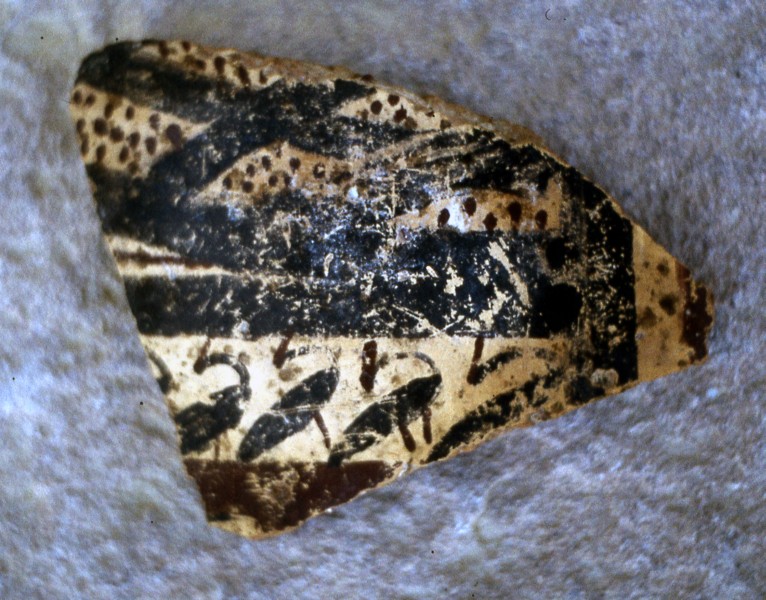
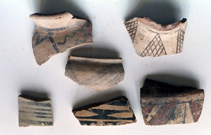
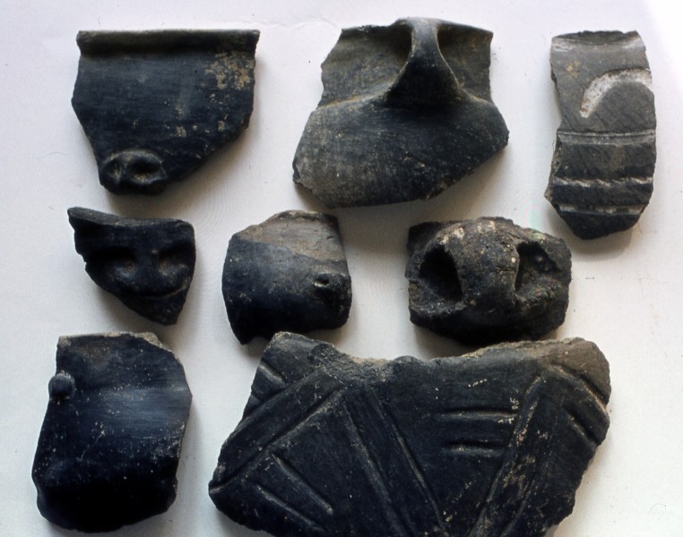
On the shores of Lake Urmia remains of the first stage of the Koura-Araxes culture (ca. 3500–2200 BC) have also been found.
Photos
33-Kura Arax pottery Excavations 1969-1978, Bastam Iran
http://www.biainili-urartu.de/Iran/Bastam/prehistory/Bastamprehistory.html
-Iran and the Kura-Araxes cultural tradition, so near and yet so far
https://books.openedition.org/momeditions/7986?lang=fr
-The spatial organization of craft production at the Kura-Araxes settlement of Köhne Shahar in northwestern Iran: A zooarchaeological approach
The Kura-Araxes cultural tradition (ca. 3500–2200 BCE) was one of the most widespread archaeological horizons in Southwest Asian prehistory, spanning from the Caucasus to the southern Levant.
https://journals.plos.org/plosone/article?id=10.1371/journal.pone.0229339
◇─◇
(13)
Lake Urmia is located in the Iranian province of Azerbaijan
Iranian Azerbaijan is generally considered the north-west portion of Iran comprising the provinces of East Azerbaijan, West Azerbaijan, and Ardabil.
The Iranian province share its borders with the modern Republic of Azerbaijan, which was an ancient iranian territory since 323 BC called Atropatene (Old Persian: Ātṛpātakāna).
Atropatene was separated from Iran in 1918 CE and named the Republic of Azerbaijan.
The Iranian province of Azerbaijan also shares borders with Armenia, Turkey and Iraq. There are 17 rivers and two lakes in the region.
More than 80 Urartian sites are now known in the province of Iranian Azerbaijan.
Photo
34-Map_of_the_historical_region_of_(Iranian)Azerbaijan https://en.wikipedia.org/wiki/Azerbaijan%28Iran%29#/media/File:Map_of_the_historical_region_of_(Iranian)_Azerbaijan.png
-Urmia, Lake
https://www.iranicaonline.org/articles/urmia-lake
-History Of Urmia
https://itoldya420.getarchive.net/amp/topics/history+of+urmia
-Tourist attractions in URMIA (city)
https://itto.org/iran/attractions/city/308-Urmia/
-IRANIAN AZERBAIJAN PATHWAY FROM THE ZAGROS TO THE CAUCASUS, ANATOLIA AND NORTHERN MESOPOTAMIA: DAVA GÖZ, A NEW NEOLITHIC AND CHALCOLITHIC SITE IN NW IRAN
https://zenodo.org/records/258086
-Iranian Azerbaijan
https://wikitravel.org/en/Iranian_Azerbaijan
-East Azerbaijan Province (Persian: استان آذربایجان شرقی Āzarbāijān-e Sharqi; Azerbaijani: شرقی آذربایجان اوستانی) is one of the 31 provinces of Iran. It is located in Iranian Azerbaijan, bordering with Armenia, Republic of Azerbaijan, Ardabil Province, West Azerbaijan Province, and Zanjan Province. The capital of East Azerbaijan is Tabriz. East Azerbaijan Province is in Regions 3 of Iran, with its secretariat located in its capital city, Tabriz.
https://dbpedia.org/page/East_Azerbaijan_province
-West Azerbaijan Province (Persian: استان آذربایجان غربی, romanized: Āzarbāyjān-e Gharbī; Kurdish: Parêzgeha Urmiyê ,پارێزگای ئورمیە, Azerbaijani: غربی آذربایجان اوستانی) is one of the 31 provinces of Iran. It is in the northwest of the country, bordered by Turkey (Ağrı, Hakkâri, Iğdır and Van Provinces), Iraq (Erbil and Sulaymaniyah Governorates) and Azerbaijan’s Nakhchivan Autonomous Republic, as well as the provinces of East Azerbaijan, Zanjan and Kurdistan. The province is part of Region 3. It is separated from Armenia by Turkey’s short border with the Azerbaijan Republic. The province of West Azerbaijan covers an area of 39,487 km², or 43,660 km² including Lake Urmia. As of the 2016 census, the province had a population of 3,265,219, in 935,956 households. The capital city and largest city of the province is Urmia.
https://dbpedia.org/page/West_Azerbaijan_province
-Urmia is the capital of West Azerbaijan Province.
https://en.urmia.ac.ir/About-Urmia
-Ardabil is historical city in Azerbaijan region of Iran.
https://wikitravel.org/en/Ardabil
◇─◇
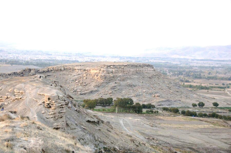
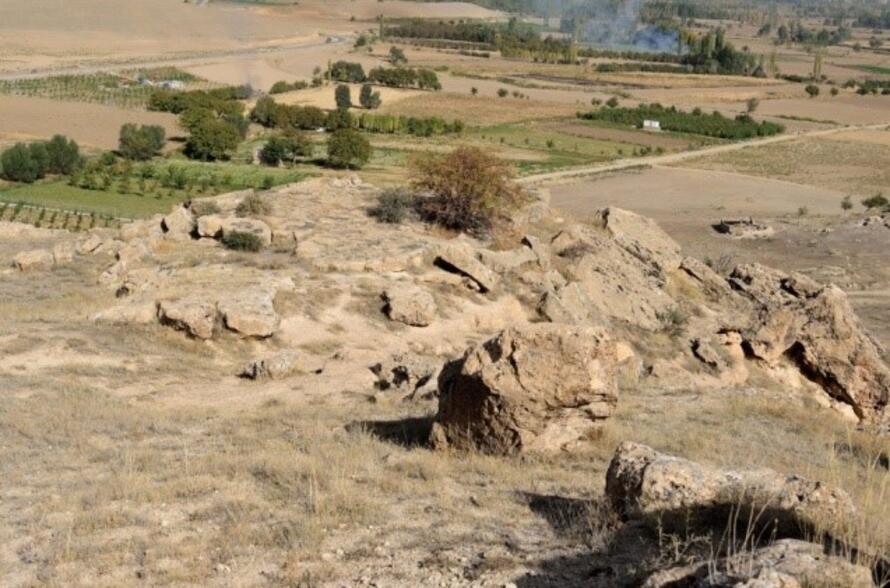
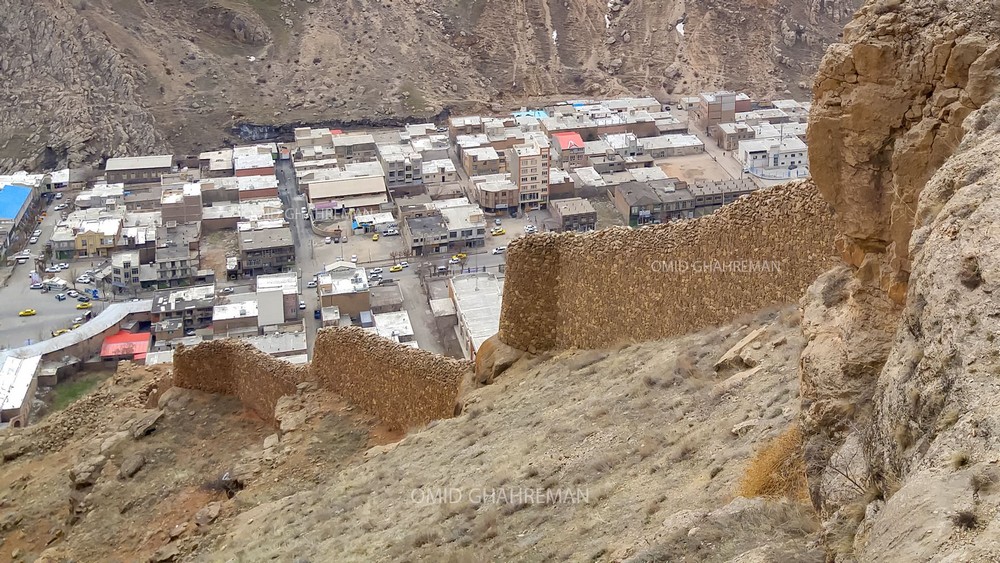
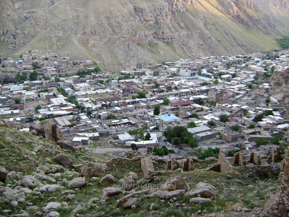
(14)
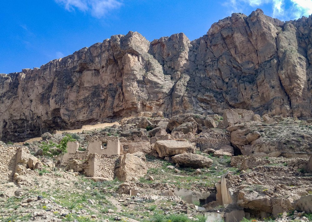
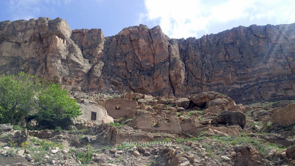
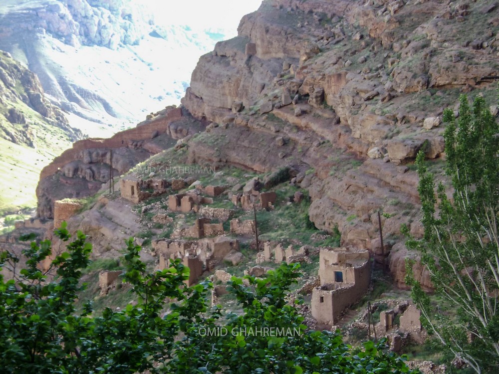
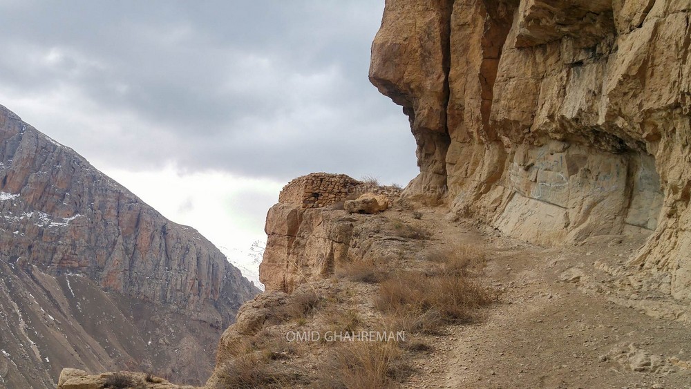
The historic village of Chors in north-west Iran, considered to be one of the first great cities of Urartian civilization.
Photos
35-chors.1
35-chors-2
The archaeological site of Chors iran
https://www.uibk.ac.at/alte-geschichte-orient/institut/team/vai/chors_nw-iran.html
The archaeological site of Chors
The fertile plains along the coastal regions west of Lake Urmia were an integrated part of the Urartian kingdom since its earliest political formation in the last quarter of the 9th century BCE
The village Chors (چورس) is located 40 km north of Khoy and 8 km southeast of Qara Zia’eddin on the southern fringe of the eponymous plain in Western Azerbaijan in the northern foothills of Safar Daghi Mountain.
The plain is watered by the river Aghchay (arm. Deghmoud) which have its sources at the 70 km distant Aktaş Dağı Mountain (2715 m) on the border between Iran and Turkey. The archaeological Hill Anaqizli is situated 200 m north of the village of Chors on a natural rock plateau on an altitude of 1725 m above sea level (Pl. 1).
The region of Chors is commonly localised as one of the most likely places of the battle of Avarayr fought between Sassanid Persia and rebellious Armenians under Vartan Mamikonian in 451 CE. Likewise, in the Parthian period the area of Khoy acted as the gateway to the Parthian Empire marched through by the Roman army under Marc Antony during the Roman-Parthian War in 40-33 BCE (Balilan Asl and Jafari 2013).
The plain of Qara Zia Eddin has recently been emphasized by Dan (2010) as a paramount example for the research of the landscape polity of the kingdom of Biainili-Urartu (Olwig 1996, 2009, 2014). The prominent position of this plain is owed to the impressive archaeological investigations which have been realised by the German Archaeological Institute (DAI) under the leadership of Wolfram Kleiss in Iranian Azerbaijan, and most notably the excavations conducted in this context at Bastam, located at the eastern access into the plain just 10 km west of Chors from 1967 to 1978 (Kleiss 1979. Kleiss 1988).
Noteworthy is the reconnaissance of a dense network of fortresses built along and across the main valley and pass routes used by the Urartian kings to control and connect the fertile plains spread over the mountainous region delimited by the three Lakes of Van, Urmia and Sevan and aptly circumscribed by Zimansky (1995) as the ‘Urartian archipelago`.
The group of fortresses depending on the major centre of Bastam is composed according to the classification of Biscione (2012: 82-83) of the seven fortresses of Qaleh Haidari, Turki Tepe, Ashagi Korul, Allahverdikand, Uzub Tepe, Duchgagi and Qaleh Oghlu. The geographical distribution of these sites clearly indicates a mainly west-east oriented alignment which points to the existence of a basic route directly connecting Bastam with the capital Tushpa on the eastern shores of Lake Van across the Zagros range.
As recently stressed by Biscione (2012: 80) the unique size of Bastam clearly suggests that this fortress represented the main political center of the kingdom of Biainili-Urartu in NW-Iran during the 7th century BCE. It connected and controlled the access both to the capital Tushpa as well as the main North-South routes from Livar in the Marand plain and Seqendel in the Avar via the fortress of Verachram into to the Ararat plain to Erebuni, Karmir Blur, Armavir and further west to Altintepe in Anatolia.
This route was, however, under control well before the foundation of Bastam as indicated by the expansion of the kingdom of Biainili-Urartu versus the Caspian Sea already under Sarduri II as evidenced by the stone inscription of Seqendel (Salvini 1982) found next to the eponymous Iron II and Iron III fortresses (Kleiss & Kroll 1980) as well as vividly recorded in the rock inscriptions of king Argišti II. (714-680 BCE) at Shisheh north-east of Ahar, at Nasht-e ban and Razliq north-east of Sarab (Khanzaq et al. 2001).
It is therefore conceivable to assume that the site of Chors was located along one of the main routes of communication since the beginning of the kingdom of Biainili-Urartu, whose policy of whatever nature has for sure affected also the history of the settlement of Chors.
This research aspect is in particular relevant in regard to fall of the kingdom of Biainili-Urartu in the 40is of the 7th century BCE. It is, namely, precisely this dramatic fate for whose investigation and dating the fortress of Bastam represents the key site, that accounts for the paramount importance of Chors for the research of the relation between Biainili on the one hand and Urartu on the other. The destruction horizon of Bastam allows, in fact, a unique archaeological ‘snapshot` of a period of occupation complemented by a markedly imperial environment covering a mere 20 to 30 years as a basis for comparative studies with the material from Chors in order to better assess the impact the foundation and fall of Bastam had had on the settlement occupation at Chors.
https://www.uibk.ac.at/alte-geschichte-orient/institut/team/vai/chors_nw-iran.html
◇─◇
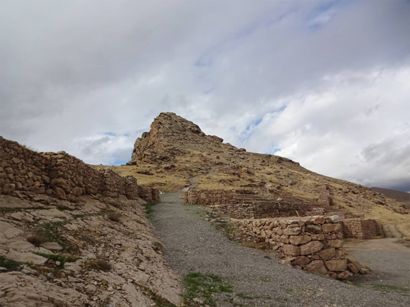

(15)
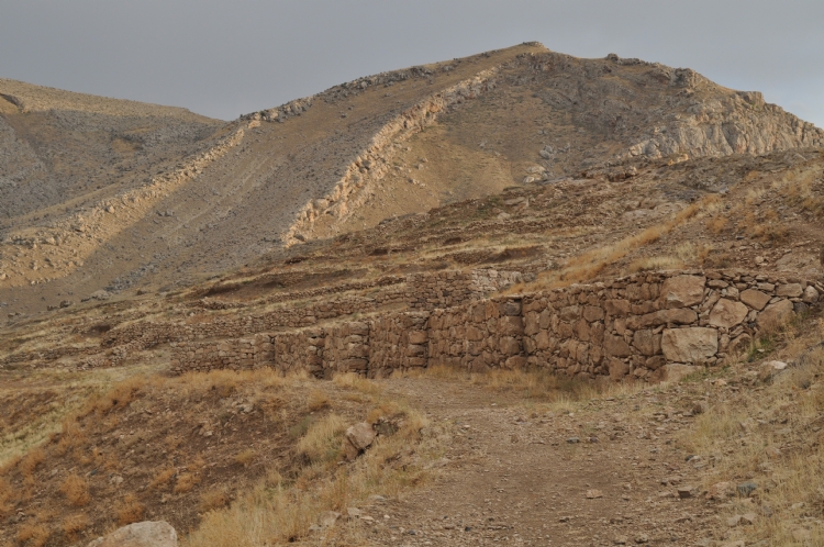
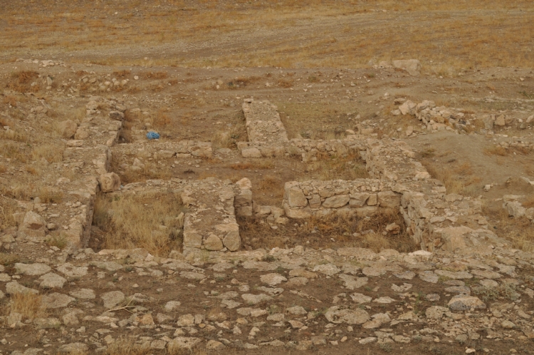
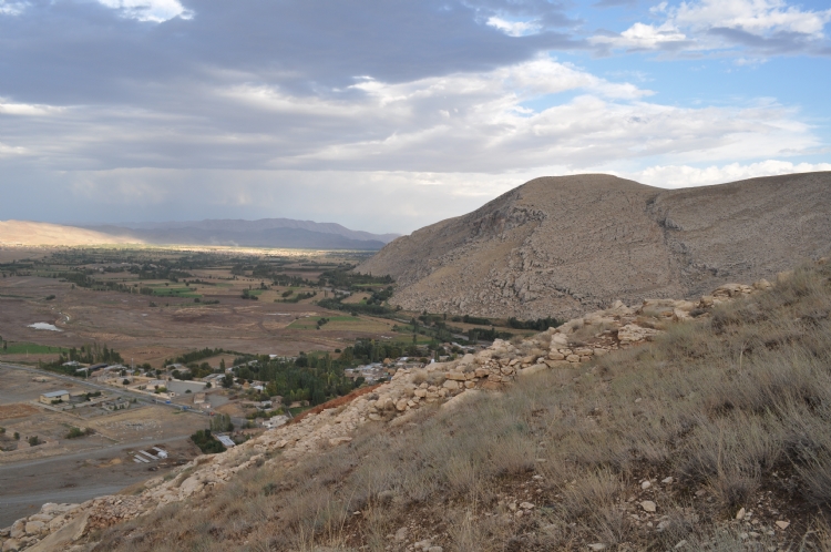
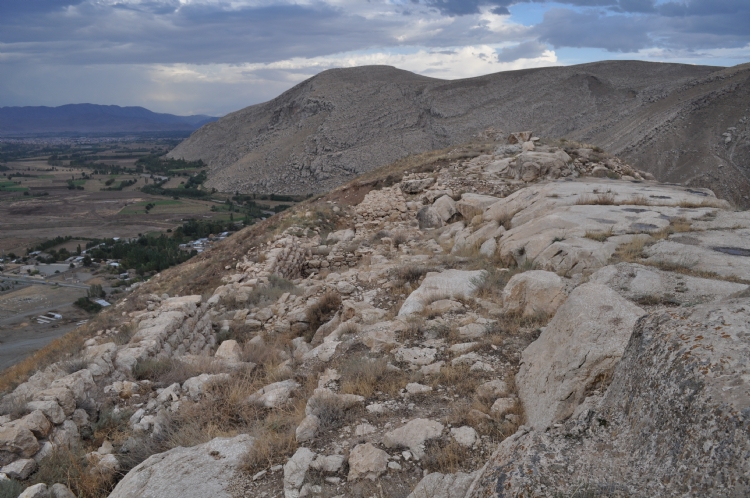
Another example is the Bastam fortress, located next to the village of Bastam, near the town of Qaraziadin, in the province of Urmia. It is said to be the largest castle in Urartian civilization.
Bastam sits atop a steep hill on the banks of the Aq Çay river, commanding a plain on a major communication route between the Urtarian capital Tushpa and Urmia.
Bastam Castle was built by the Urartu people and was for some time one of the most important protected and inaccessible places in the Urartu civilization, where no one could enter.
The area had been part of Urartu since the 9th century BC and a small fortress was built at that time, which was later demolished when the large citadel was planned.
Bastam only came to prominence in the first half of the 7th century BC, when the Urartian King Rusa II (Rusa, son of Argishti, c. 675-650 BC) reorganized his Kingdom.
Bastam was the most powerful of the fortresses built under this King, but its power was short-lived, as it was conquered towards the end of Rusa II’s reign, possibly by Scythians.
The fortress measures around 800 m by 400 m and is arranged on three levels.
The building material is dried brick on a stone foundation. The fortress is protected by ramparts with rectangular towers and buttresses.
The entrance to the lower part is through a single gate to the south, flanked by a tower. This part of the citadel houses the garrison barracks, stables with room for 60 horses, a mill, kitchens and small stores.
In the middle section, grain, wine and oil were stored in large warehouses. The burnt bones of several hundred animal carcasses have also been found. Next to this is a platform on which stood the temple-tower mentioned in the foundation inscriptions, dedicated to the God Haldi.
The upper part is the royal residence, where fragments of painted plaster have been found.
In the opposite plain to the fortress, a fortified complex has been found, linked to horse-breeding. And at the foot of the hill, to the north, lies a residential area, where officials and merchants were accommodated.
The Urartian text found in Bastam Castle is preserved in Tehran’s National Museum. Bastam Castle was inscribed on Iran’s national heritage list in 1972.
Photos
36-Bastam Castle Iran
37
38
39
40
41
https://www.visitiran.ir/en/attraction/Bastam–Castle
https://www.kojaro.com/attraction/7347-bastam-castle/
(To see more photos)
-Ruins of Urarten fortress, 7th century BC, archeological site, Bastam, West Azerbaijan Province, Iran
https://www.alamy.com/ruins-of-urarten-fortress-7th-century-bc-archeological-site-bastam-west-azerbaijan-province-iran-image271821702.html
-BESṬĀM (2)
https://iranicaonline.org/articles/bestam-2
-Excavations of the ancient Urartian fortress Bastam (Iran-Azarbayjan – 1969-1978)
http://www.biainili-urartu.de/Iran/Bastam/Bastam.htm
-The newly-donated Urartian inscription from Bastam by Rusa II
https://www.academia.edu/90119970/The_newly_donated_Urartian_inscription_from_Bastam_by_Rusa_II
-The Newly-Donated Urartian in Scription from Bastam by Rusa II
https://jarcs.ut.ac.ir/article_88271_7651138218cf845164c162a2be4cda51.pdf
-Newly Found Bulla from Urartian Site of Bastam in Iran
The area around three Lakes Sevan, Van and Urmia was conquered or ruled by the Urartian kingdom for about three centuries, approximately from the 9 th to 6 th centuries b.c.
Many different inscribed objects and stones are found from this culture. These pieces of evidence contribute to the detailed information we presently have about Urartian kingdom and people.
Urartian kings built many constructions and left perhaps equally as many varied inscriptions. Rusa II, son of Argishti II, constructed many cities and fortresses, including Bastam, roughly during the frst half of the seventh century b.c.
Fortifcations as Toprak Kale, Kef Kalasi, Ayanis and Karmir-blur were of particular signifcance and noticeable for establishment and development of Urartian kingdom power (Belli 2003-3004: 68).
https://www.academia.edu/41027249/Newly_Found_Bulla_from_Urartian_Site_of_Bastam_in_Iran
-Exploring the Southeast Frontier of the Urartian Kingdom. The Qara Zia-eddin-Survey: An Archaeological Prospection of Anaqizly Tappeh
The Qara Zia-eddin plain is considered a prime example of land use in Southeastern Urartu in the Khoy region of West Azerbaijan.
Since 2016, archaeological investigations have been carried out in the Bastam hinterland through the Iranian-Austrian cooperation with the aim of investigating the interaction of settlements with local hilltop fortresses and the use of landscape use in the time of the Urartian Kingdom. The starting point of the project work was in the south of the Qara Zia-eddin plain, with the special focus on the range of hills near the village of Chors. The Urartian fortified settlement of Anaqizly Tappeh was explored using both geomagnetic and archaeological surveys.
https://www.magiran.com/paper/2495185/exploring-the-southeast-frontier-of-the-urartian-kingdom-the-qara-zia-eddin-survey-an-archaeological-prospection-of-anaqizly-tappeh?lang=en
◇─◇


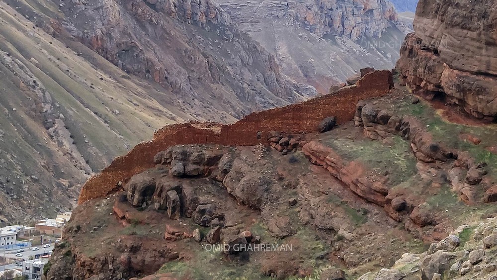
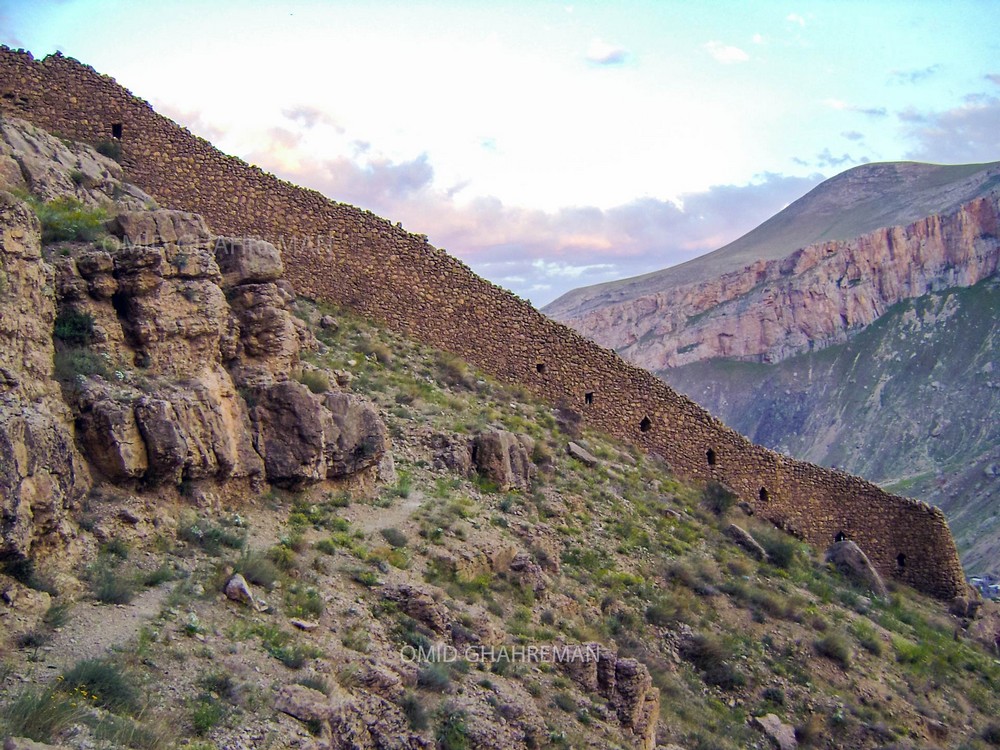
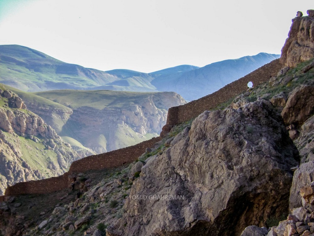
(16)
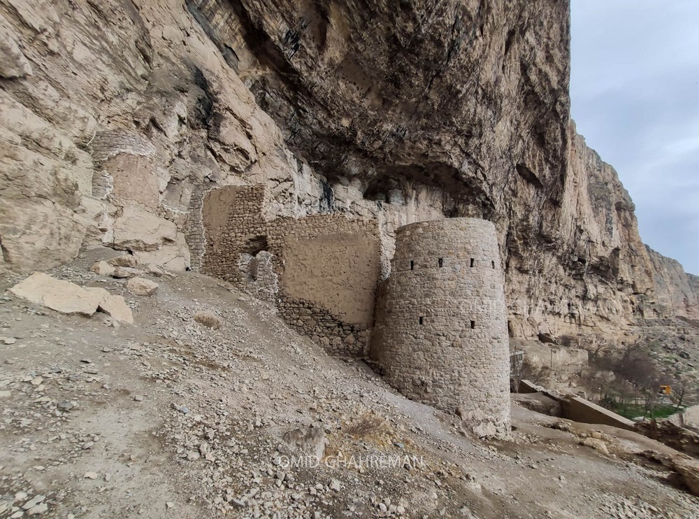
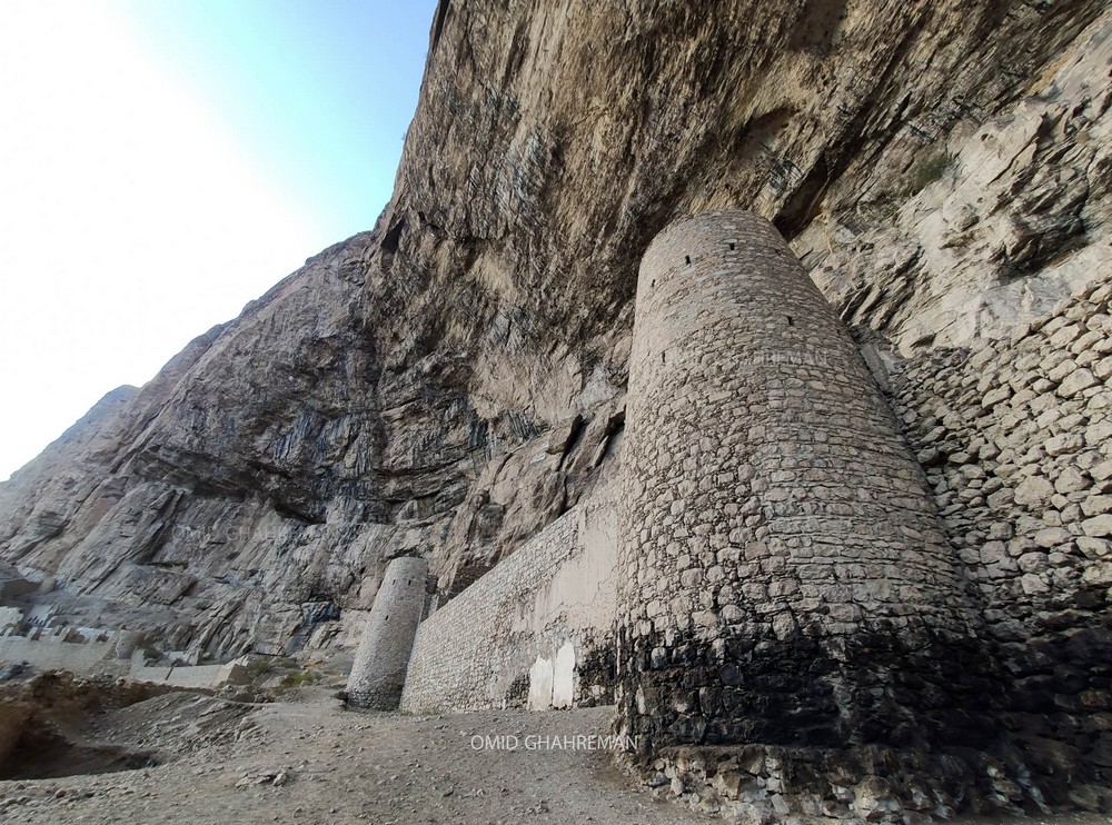
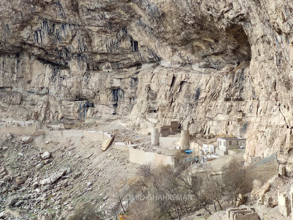
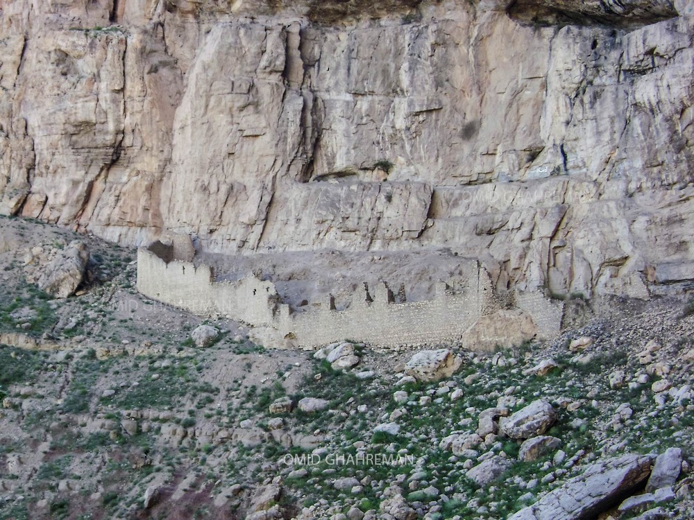
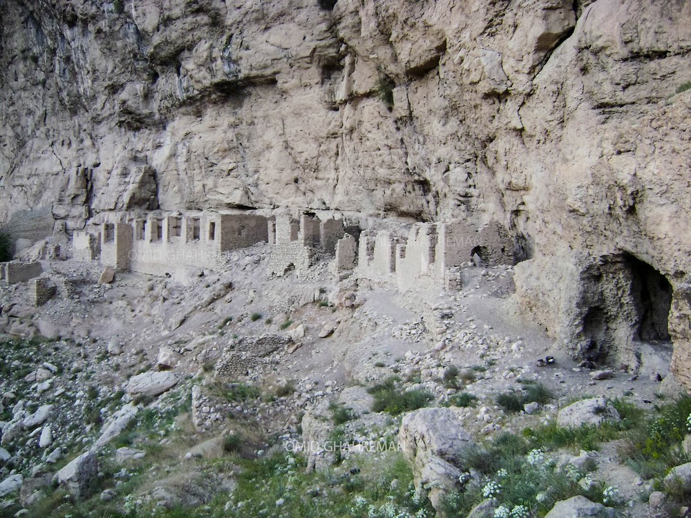
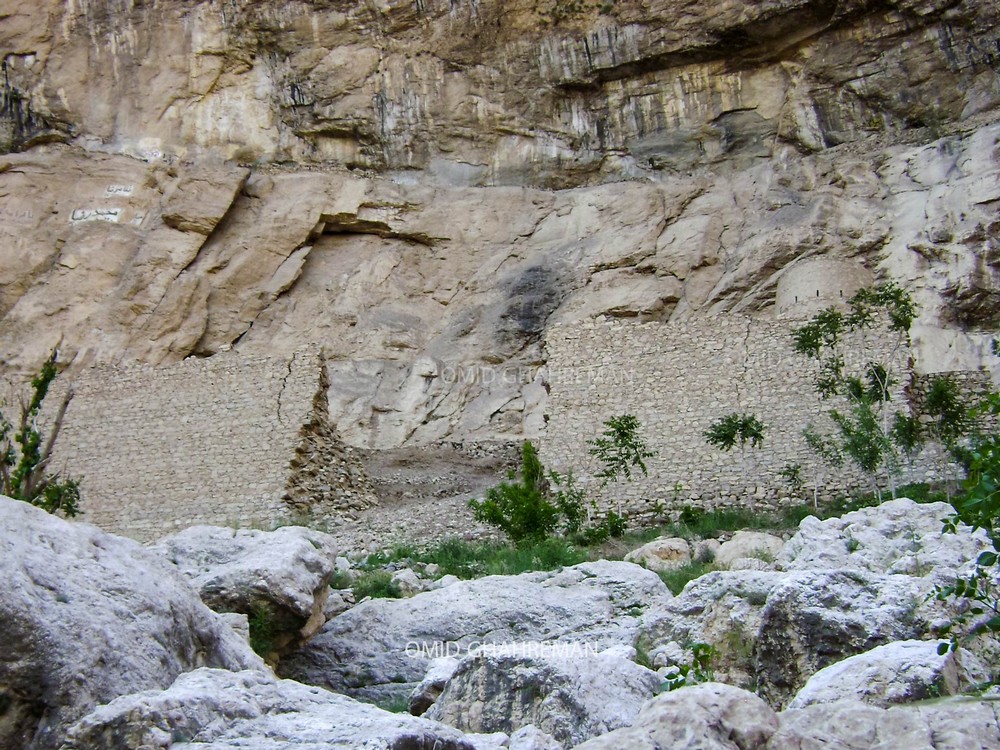
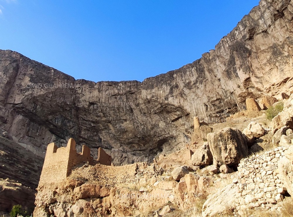
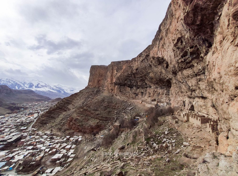
Also from the Urartu period, the Qoban Castle at Maku in the Iranian province of West Azerbaijan.
Remains of the Stone and Iron Ages are abundant in this region, making it an interesting place to visit.
In ancient times, the term “Qaban” was used to name fortresses and certain places or areas.
Qaban Castle was built by the Urartu Empire (7th-8th centuries BC) and over the centuries, as the region came under the rule of various governments and individuals, the castle’s architecture was modified to suit religious, military and residential uses, and much of it was destroyed during the reign of Shah Abbas Safavid.
This historic monument was built on flat ground created by cooled molten materials (volcanic soil).
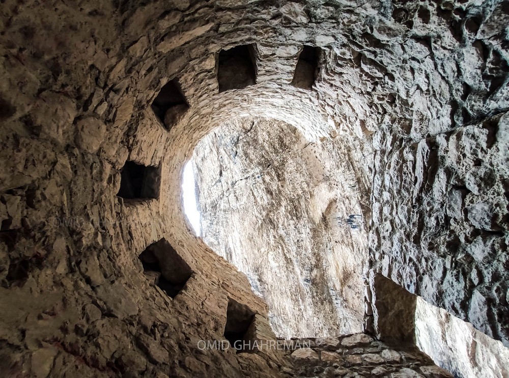
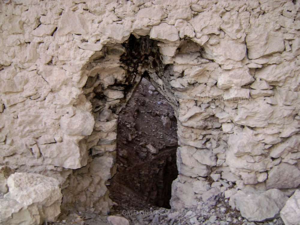
The castle consisted of several observation turrets.
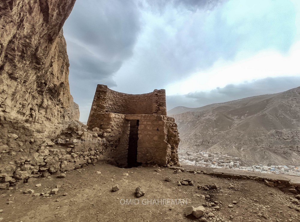
The southern part of the castle included a bazaar, a public bath, a place of worship and a place for keeping livestock. In the western part of the castle, there is a large kitchen, some of which is still intact.
Inside the castle, there are very large underground vats that were used to store food and perhaps objects of value.
And beneath the castle’s eastern houses, there are warehouses that have been insulated with clay to prevent moisture penetration and also to be used as refrigerators to store food.
At the eastern summit of the castle, there are the carved foundations on which the wooden beams of the roofs of the houses and perhaps the bases of the staircases rested.
The rooms were all connected to each other by doors to facilitate movement and evacuation of people if necessary or during military attacks.
On the eastern side of the houses of the castle, there is a large stone with carvings from the period of Armenian domination, including crosses and inscriptions; its inscriptions concern the deaths of several great figures and their burials.
Photos
42-Qoban Castle Maku Iran.1
Omid Reza Ghahremanzadeh
https://omidghahreman.ir/%D9%85%D8%B9%D9%85%D8%A7%D8%B1%DB%8C-%D8%AA%D8%A7%D8%B1%DB%8C%D8%AE%DA%86%D9%87-%D9%82%D9%84%D8%B9%D9%87-%D9%82%D8%A8%D8%A7%D9%86-qaban-castle/%D9%85%D8%A7%DA%A9%D9%88/#:~:text=%D9%82%D9%84%D8%B9%D9%87%20%D9%82%D8%A8%D8%A7%D9%86%20%D8%B8%D8%A7%D9%87%D8%B1%D8%A7%20%D8%AA%D9%88%D8%B3%D8%B7%20%D8%A7%D9%85%D9%BE%D8%B1%D8%A7%D8%B7%D9%88%D8%B1%DB%8C,%D8%A7%D8%B2%20%D8%A2%D9%86%20%D8%AA%D8%AE%D8%B1%DB%8C%D8%A8%20%DA%AF%D8%B4%D8%AA%D9%87%20%D8%A7%D8%B3%D8%AA%20.
◇─◇
(17)
We can also mention the Urartu Bari Castle, Urmia Lake Iran
Bari Castle is located on the western side of Urmia Lake.
The castle enclosed with stony walls measuring several meters high, encompasses a widespread area.
It was used in the first millennium BC considering the castle’s architectural features and potsherd remains found on its surface.
For almost 150 years, from the middle of the 9th century to the end of the 8th century, the Urartian areas in Iran did not witness any attack from Assyrians.
It was only during the reign of Sargon II, clashes erupted between Urartu and Assyria.
The reason was that Urartu interfered more and more in the affairs of the kingdom of Mannea, which Assyria considered a tributary.
The first half of the 7th century is when Mannaean seized the power in that area.
It was the time which saw the expansion of Mannean more than ever, especially its dominance on the Urmia plain, hence; the Bari castle was of the Mannaean Empire.
-The Iron Age III of Urmia Lake Basin in the Light of New Research
Bari Castle is located on the western side of Urmia Lake.
https://jcp.modares.ac.ir/article-27-25380-en.pdf
https://en.civilica.com/doc/2198905/
*
As well as Urartu Castle at Hasanlu in the Iranian province of West Azerbaijan
Hasanlu lies to the south of Lake Urmia, a region that has been inhabited in various stages since the sixth millennium BC.
-The destroyers of Ḥasanlu IV were probably Urartians from the northwest, who at some time in the 8th century B.C.E. built a walled settlement over the ruins—Ḥasanlu IIIB (unpublished); Dinkha Tepe was abandoned.
https://www.iranicaonline.org/articles/iron-age
-Hasanlu, the Southern Caucasus and Early Urartu
https://www.academia.edu/39125163/Hasanlu_the_Southern_Caucasus_and_Early_Urartu
-The Hasanlu VII Culture in the Southern Lake Urmia Basin, Northwest Iran: A New Archaeological Outline
https://jarcs.ut.ac.ir/article_81167.html
*
-Urartian Fortifications in Iran
https://www.academia.edu/2449695/2012_Urartian_Fortifications_in_Iran
-Fortresses and castles of the first millennium BC on the southern part of lake Fortresses and castles of the first millennium BC on the southern part of lake Urmia, Iran
For a long time, Northwest of Iran have played a very special role in Iran’s history due to its political and cultural importance and mineral reserves.
Because of its specific ecological and strategic conditions, this area had experienced many economical and military changes during its history and, hence, was an important target for neighbours’ invasions. In the late 9 th century BC, Urartu’s economic, political and cultural power increased, and they seized part of Manna, a region around Urmia Lake. Urartian influence in northwest of Iran was due to strategic reasons and for preventing a dominant Assyrian power. Since the late second millennium BC and the first half of the first millennium BC, this region have frequently invaded by Assyrians. In order to confront these invasions, Urartian and Mannaean people constructed many castles in the region. It seems that the castles constructed by people contemporary with Urartians, specially the Mannaean ones, were imitations of Urartian castles exists.
https://www.academia.edu/35646523/Fortresses_and_castles_of_the_first_millennium_BC_on_the_southern_part_of_lake_Fortresses_and_castles_of_the_first_millennium_BC_on_the_southern_part_of_lake_Urmia_Iran
-Ancient Settlement Inhabited By Urartian People
Iranian archaeologists have found an ancient settlement in the northwestern part of the country, near Beygush Tepe, an archaeological site in Chaldoran county, West Azarbaijan province.
The archaeological evidence suggests that the site was once home to people from the Urartu Kingdom and it most probably flourished during the New Bronze Age in the first millennium BC which was confirmed by potteries that were unearthed in the area.
https://www.tehrantimes.com/news/453500/Ancient-settlement-attributed-to-Urartu-kingdom-identified-in
https://www.ancientpages.com/2020/10/13/ancient-settlement-inhabited-by-urartian-people-unearthed/
Oshnavieh is situated in West Azarbaijan province, Oshnavieh boasts some 100 sites registered on the national cultural heritage list.
It is also home to archaeological sites and hills, tomb chambers, and bas-relief carvings belonging to the Kingdom of Urartu (860 BC – 590 BC).
-Oshnavieh
https://mapcarta.com/12589268
◇─◇

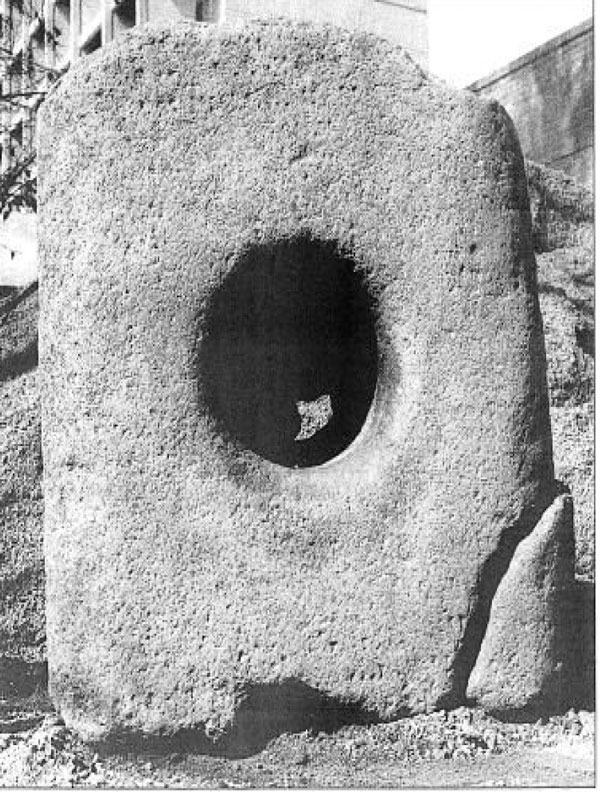
(18)
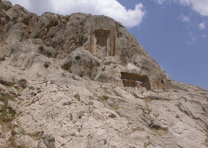
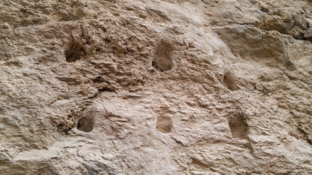
In addition, in Iran, there are several Catacombs from the Urartui (858 – 585 BC) period, but also from the Medes (625 – 585 BC) period, as well as Catacombs from the Iranian/Achaemenid Empire (556 – 330 BC) period.
The word “catacomb” comes from the Latin “catacumbæ” meaning “underground cemetery”.
And the Persian word “Dakhma” refers to a catacomb or tomb.
Catacombs are generally man-made underground passages used mainly for funerary and religious purposes.
Some catacombs consist of just one hole, as in the case of the Urartuian catacombs; in the case of the Medes, the catacombs were larger, with two or three rooms that people could enter.
And under the Iranian/Persian, Achaemenid Empire, the catacombs will be even bigger, with impressive sculptures surrounding the catacomb entrance.
Elsewhere in the world, there are much larger catacombs, some of them covering many kilometers.
There’s not much information on Urartuian burial rites, but evidence left by the Medes, who took over the region and also used catacombs for burial purposes, suggests that Urartuian and Median burial rites were more or less similar.
For the Medes, as for the Zoroastrians, corpses were considered impure, and in order to scrupulously avoid any contamination of the earth, fire or water, they were exposed to vultures. Corpses were placed on rocks so that no other animal could be contaminated, and that only the vultures could reach them.
Once the corpses have been reduced to skeletal and considered purified, the bones are placed in a hole. Under Zoroastrianism, towers of silence were built, the best-preserved example being the Tower of Silence in Yazd.
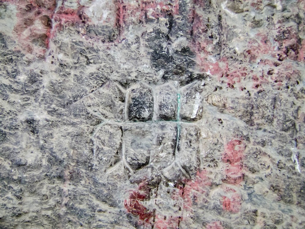
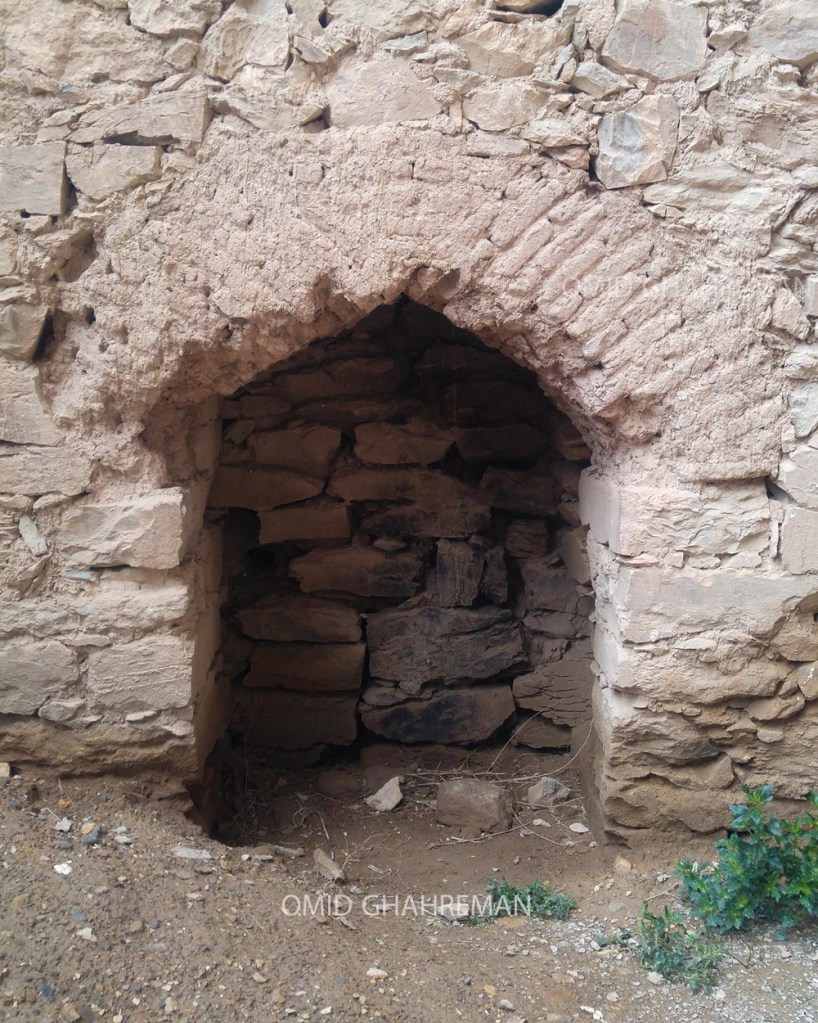
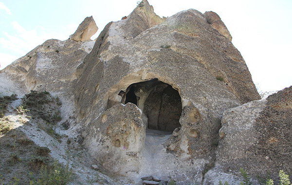
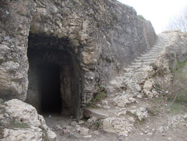
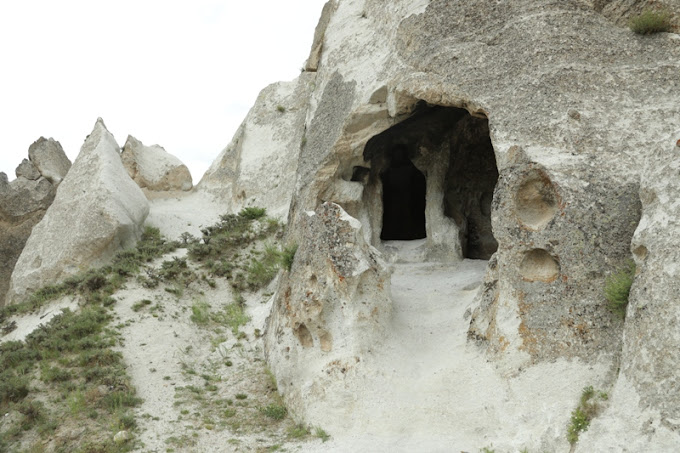
In these photos, the Urarian catacombs, dating from the 8th century BC.
These catacombs are located 7 km northwest of the town of Maku, near the village of Sangar, in the Iranian province of Azerbaijan.
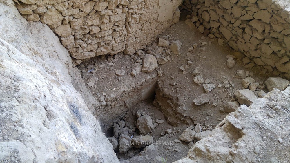
These catacombs are astonishingly smooth; carving such smooth walls amidst the hard rock of the mountain seems really difficult, even today.
The catacombs consist of two interlocking rooms dug into the heart of the mountain and into a large boulder, which is connected to the mountain by a 30-step stone staircase.
One of these catacombs has an entrance measuring around 1.5 meters by 2 meters, and the rooms are large (around 3×4) and the other smaller (around 2×2), which are connected by a 1×1.5 meter door.
Niches were carved into the walls and torches were used for lighting.
The monument was inscribed on Iran’s national heritage list on March 21, 1968.
Unfortunately, all these catacombs have been looted over time, motivated by the absurd discovery of treasure, breaking most of the interior parts of the tombs, causing irreversible damage.
For a long time now, there has been a myth about these catacombs, which locals attribute to Farhad. Farhad is a famous character from Persian literature and mythology.
The story of his love for Shirin is one of the most famous love poems of Persian culture and the Iranian world, completed in 1180 CE by the famous Iranian poet Nizami (b. 1141, d. 1209 CE).
This work is an elaborate fictive version of the Iranian Sassanid King Khosrow II’s love affair with the Armenian princess Shirin, who becomes Queen of Iran/Persia.
And the locals believe that Farhad carved one of the tombs and that Farhad and Shirin are buried there. But that’s not true.
But that’s why these catacombs of Urartuian origin are known as the (Tomb of Shirin and Farhad).
Photos
43-Urartu Catacomb Azerbaijan Iran
https://en.irancultura.it/tourism/attractions/Azerbaijan-West/the-tomb-of-shirin-and-farhad/
-The sepulcher of Shirin and Farhad
It is a rock tomb carved into the wall of a mountain and has some rooms. It goes back to the first millennium a. C. and belongs to the period of Urartu.
https://en.irancultura.it/tourism/attractions/Azerbaijan-West/the-tomb-of-shirin-and-farhad/
-Zoroastrian Towers of Silence
https://www.atlasobscura.com/places/zoroastrian-towers-of-silence
-Tower of Silence
https://mapcarta.com/W239508111
-Nezami Ganjavi the Renowned Iranian Poet
https://bs.icro.ir/Celebrities/Nezami-Ganjavi-the-Renowned-Iranian-Poet
◇─◇
(19)
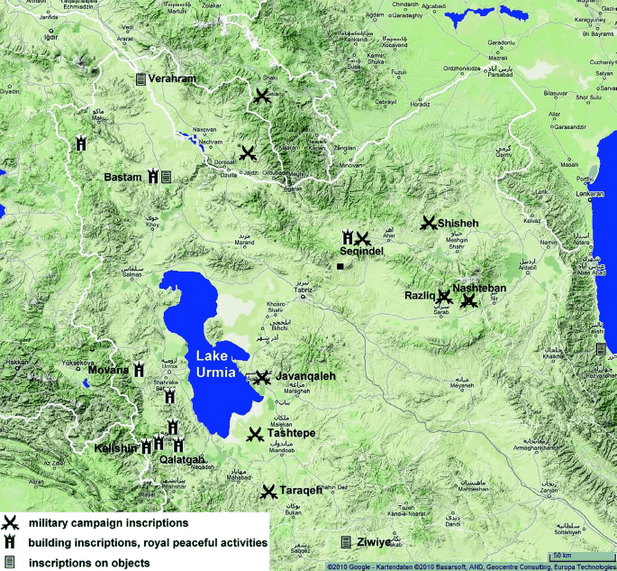
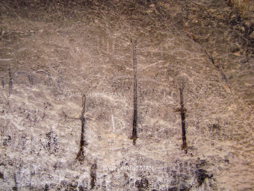
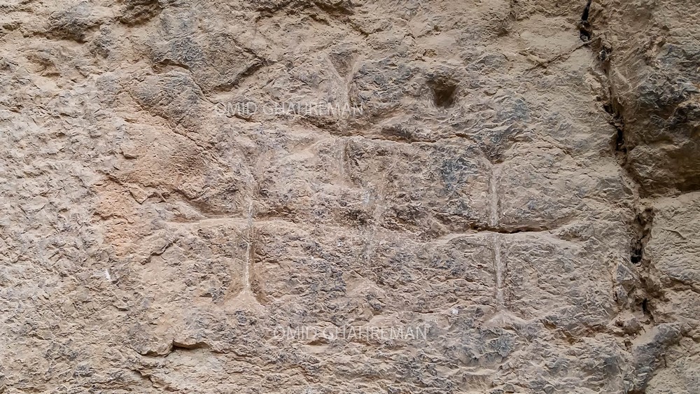
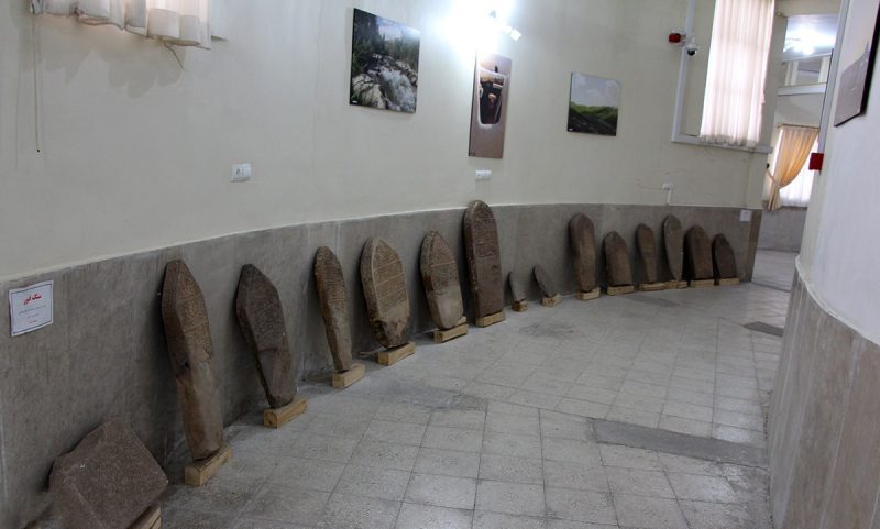
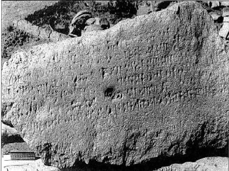
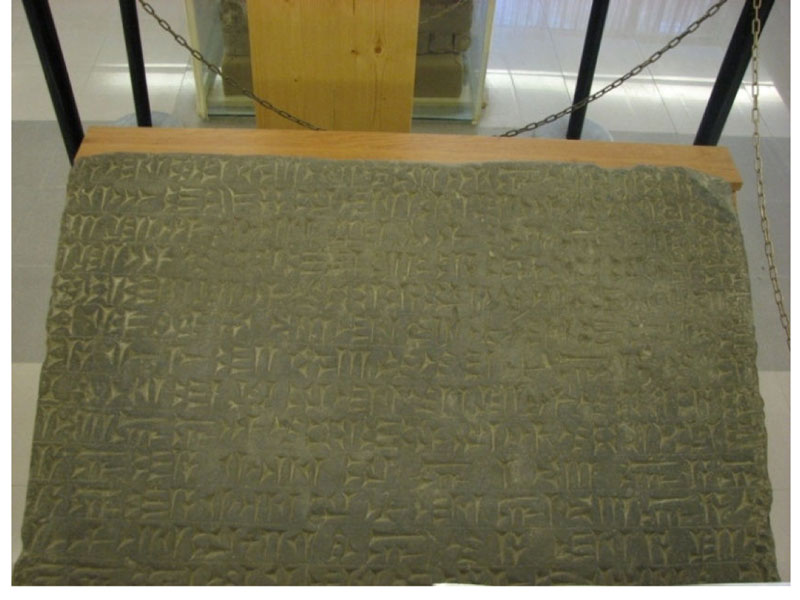
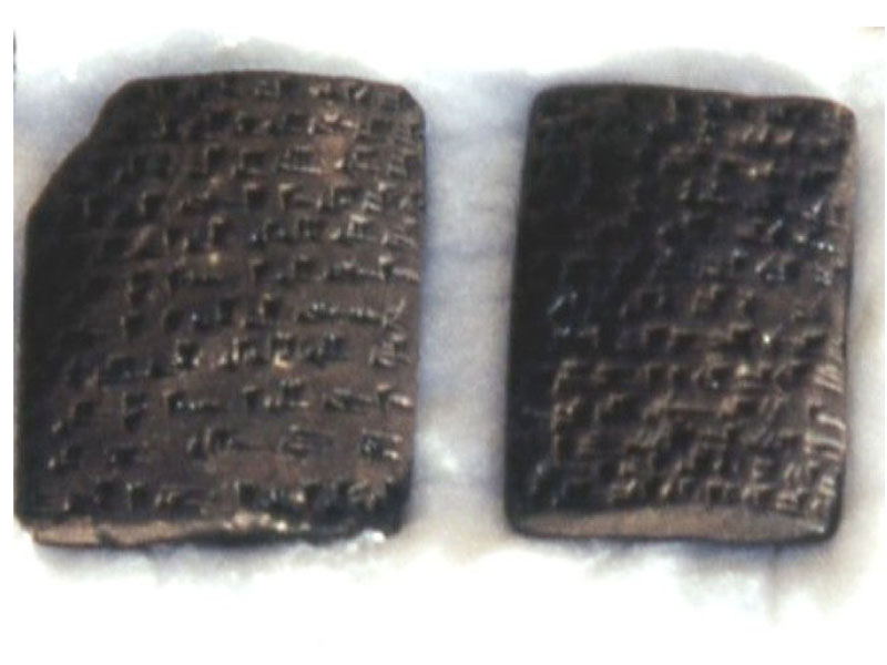
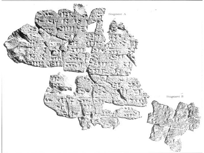
Urartu cuneiform inscriptions in Iran
Two centuries of Urartu presence in north-western Iran had a major influence on the region’s cultural, social and civil life.
Ishpuini, the son of Sardori, the third King of Urartu, was the first to enter the north-western region of Iran and left inscriptions there. After him, other Urartu Kings too made inscriptions in this region of Iran.
The text of these inscriptions mainly includes prayers, sacrifices to the Gods, offerings, war actions, descriptions of campaigns and the construction of Temples and public and civil places.
These inscriptions are in Urartian cuneiform script, sometimes bilingual (Urartian and Assyrian).
In the Iranian province of West Azerbaijan, research by national and foreign archaeologists has so far uncovered ten major Uratarian inscriptions and a number of smaller ones.
Other Uraltarian inscriptions have also been found outside the Iranian province of West Azerbaijan.
Several of his inscriptions can be seen in the Urmia museum.
Photos
44-Urartu Inscriptions Iran.1
https://paymanonline.ir/%da%a9%d8%aa%db%8c%d8%a8%d9%87-%d9%87%d8%a7%db%8c-%d8%a7%d9%88%d8%b1%d8%a7%d8%b1%d8%aa%d9%88%db%8c%db%8c-%d8%af%d8%b1-%d8%a2%d8%b0%d8%b1%d8%a8%d8%a7%db%8c%d8%ac%d8%a7%d9%86-%d8%ba%d8%b1%d8%a8%db%8c/
-Urmia Museum Iran
https://epiciran.com/place/urmia-museum/
-Urartian inscription of kings Ishpuini and Menua, from the surface at Qalatgah Iran.
https://www.penn.museum/sites/expedition/qalatgah/
-Inscription of the Urartian King Menua
https://www.worldhistory.org/image/7113/inscription-of-the-urartian-king-menua/
-The Newly-Donated Urartian in Scription from Bastam by Rusa II
https://jarcs.ut.ac.ir/article_88271_7651138218cf845164c162a2be4cda51.pdf
-Introducing Newly Documented Rock Art in Mianeh County of the East Azarbaijan Province in North-Western Iran
https://publikace.nm.cz/en/file/6c669320ca69643dc459eaed952d2a56/35273/ANNALS_43-01-2022_Ramin.pdf
-THE URARTIAN ROCK INSCRIPTIONS OF RAZLIQ AND NASTEBAN (EAST AZERBAIJAN, IRAN)
http://smea.isma.cnr.it/wp-content/uploads/2016/02/Salvini_The-Urartian-Rock-Inscriptions.pdf
-Urartu Segendel inscription
https://www.kojaro.com/attraction/7010-seghendel-epigraphy/
https://www.wikiloc.com/trails/outdoor/iran/azarbayjan-e-sharqi/saqam-del
-The inscription of the village of Shisha
The village of Shisha is located near the south of the village of Shirbit in the Iranian province of East Azerbaijan.
In the archaeological surveys that were carried out in this area in 1998, a rock inscription was discovered. The inscription was written in cuneiform script and Urartian language. The translation of the surviving text on the inscription dates back to the reign of Argisti II. He was the ninth king of Urartu, who ruled between 714 and 680 BC. The Urartu were kings in the Iron Age whose territory encompassed the lands around Lake Urmia, Lake Van, the mountains of Armenia, and parts of present-day Turkey.
They ruled from 860 to 600 BC and controlled the trade of the Caucasus region and the Caspian Sea. This led to a lot of wealth in the hands of this government. This wealth can be seen in the special and majestic architecture of the buildings left over from that period. The existence of these buildings shows that the Urartu people had an advanced civilization compared to their time. The effects of this civilization on the architecture and civilization of the Medes and Achaemenids, who later ruled Iran, are evident.
https://seeiran.ir/%D9%82%D9%84%D8%B9%D9%87-%D8%B4%DB%8C%D8%B1%D8%A8%DB%8C%D8%AA/
-The Spread of the Cuneiform Culture to the Urartian North (IX–VII Century BCE)
https://www.mprl-series.mpg.de/proceedings/7/16/index.html
https://www.mprl-series.mpg.de/media/proceedings/7/16/proc7chap14.pdf
*About cuneiform writing, a writing system was used in Iran 4,400 years ago.
Linear elamite, a writing system used in Iran 4,400 years ago
François Desset has managed to decipher Linear Elamite, a writing system used in Iran 4,400 years ago. In its archaic proto-Elamite version (as early as 3300 BC), it joins the two oldest known writing systems in the world, the proto-cuneiform of the Mesopotamians and the Egyptian hieroglyphics.
Enough to change the knowledge we had until then about the origin of writing!
https://leparisdepatrick.com/en/linear-elamite-a-writing-system-used-in-iran-4400-years-ago/
◇─◇
(20)
Urartian Bulla from Ziwiye in the northwestern of Iran
Bullae are small lumps of clay, often fingernail-sized and shaped as flat disks, which were usu- ally affixed to a cord binding a commodity or a document and then stamped with a seal.
Bullae or clay sealings were used in ancient Mesopotamia and in Iran as well, but strictly speaking bullae came into general use after the end of cuneiform writing.
Photo
45-Urartian Bulla in Ziwiye Iran
https://journals.akademicka.pl/saac/article/view/5739
-The Origin of the Discovered Urartian Bulla in Ziwiye
There are several discovered Urartian artifacts and among them are the bullae. They are sometimes inscribed and sealed with cylinder and/or stamp seals.
The impressions sometimes contain an inscription along with a royal, mythical or ritual scene. Royal impressions include the figure and the inscription of King Rusa II. There is an Urartian bulla from Ziwiye with a stamp seal impression representing Rusa’s figure, a parasol over his head and an inscription which resembles the impressions of Ayanis bullae. Additionally, cylinder seal impressions with similar iconography and inscription are discovered in Bastam and Toprakkale. There are previous contributions on the bulla of Ziwiye but none are about its inscription or the detail of the impression in comparison with other bullae. The inscription on the bulla from Ziwiye as Dḫal-di URU (the city of God Ḫaldi). There were several cities of Ḫaldi in the Urartian kingdom but as the impression of Ziwiye bulla resembles to bullae of Ayanis, it is possible that the city this bulla came from was close to or under the control of Ayanis.
https://journals.akademicka.pl/saac/article/view/5739
-Archaeological Scrap Glimpses of History at Ziwiye
https://www.penn.museum/sites/expedition/archaeological-scrap/
◇─◇
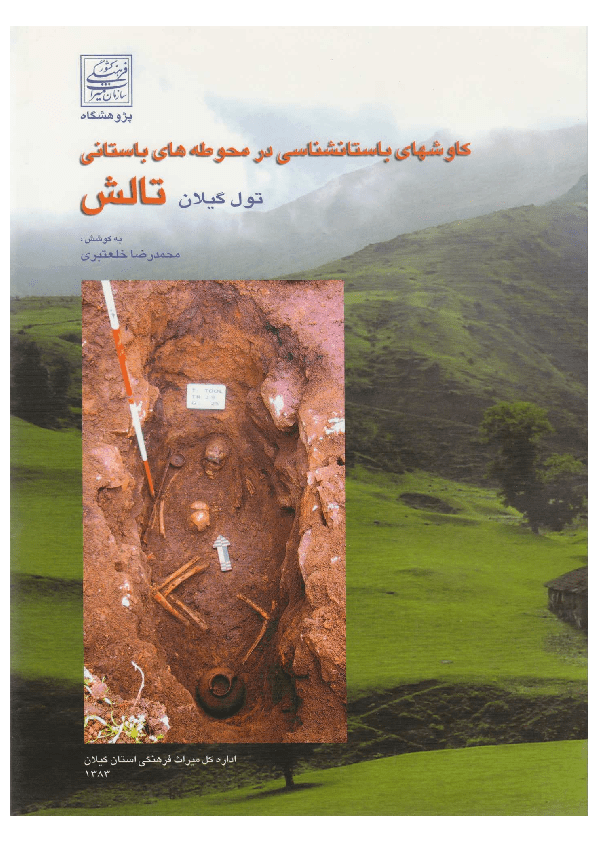
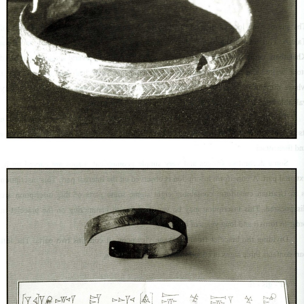
(21)
A Bronze Bracelet with Urartian Inscription from Toul, Gilan, (in Persian) Archaeological Excavations in Ancient Sites of Talesh, Toul of Gilan, by M.R. Khalatbari, published by Cultural Heritage Office of Gilan Province: 91-97.
https://www.academia.edu/2390475/
Photos
46-Bronze Bracelet with Urartian Inscription from Toul, Gilan
https://www.academia.edu/2390475/_A_Bronze_Bracelet_with_Urartian_Inscription_from_Toul_Gilan_in_Persian_Archaeological_Excavations_in_Ancient_Sites_of_Talesh_Toul_of_Gilan_by_M_R_Khalatbari_published_by_Cultural_Heritage_Office_of_Gilan_Province_91_97
◇─◇
Mapping Ancient Urartu
An Interactive History of Urartian Archaeology and Decipherment, 1826–1996
https://storymaps.arcgis.com/stories/7c8f30b861084bd7a59d50de908b7430
Urartian Mass Deportation: Punishment or Policy ?
The main issue of this research is to determine the approach to mass deportation by the Urartu state. Based on this, the following questions have been raised: What are the reasons and significance of mass deportation by the Urartu state?
How can the approach and consequences of mass deportation during the time of Urartu be explained?
https://www.jaco-sj.com/jufile?ar_sfile=2591981
